
The first in a series of articles about historic highway signage. We will be featuring many, many more articles, on a great variety of sign-related topics, on the AARoads Shield Gallery.
This Midland Trail overview is made possible by the indispensable research of Devon Mich’l, the foremost authority on Nevada highway signs in general, and especially the Midland Trail. All accurate facts in here are to be credited to Devon. Any misinformation, on the other hand, is certainly due to my oversight!
Overview
The Midland Trail was an unimproved wagon trail dating to the 1860s that crossed central Nevada and served the silver and gold camps of Tonopah and Goldfield in the early 1900s. It was still nothing more than a dirt trail in 1913 when it received its name, Midland Trail, as part of a much longer transcontinental route of that name. It became the first road in Nevada to be federally funded.
In this article, I talk only about the westernmost section of the Midland Trail, from Ely, Nevada (where it met the Lincoln Highway) to its terminus in Los Angeles.
The Automobile Club of Southern California marked the route very well, starting in 1915. With the Midland Trail well marked from Ely, Nevada to Los Angeles, Southern California was now connected to the Lincoln Highway.

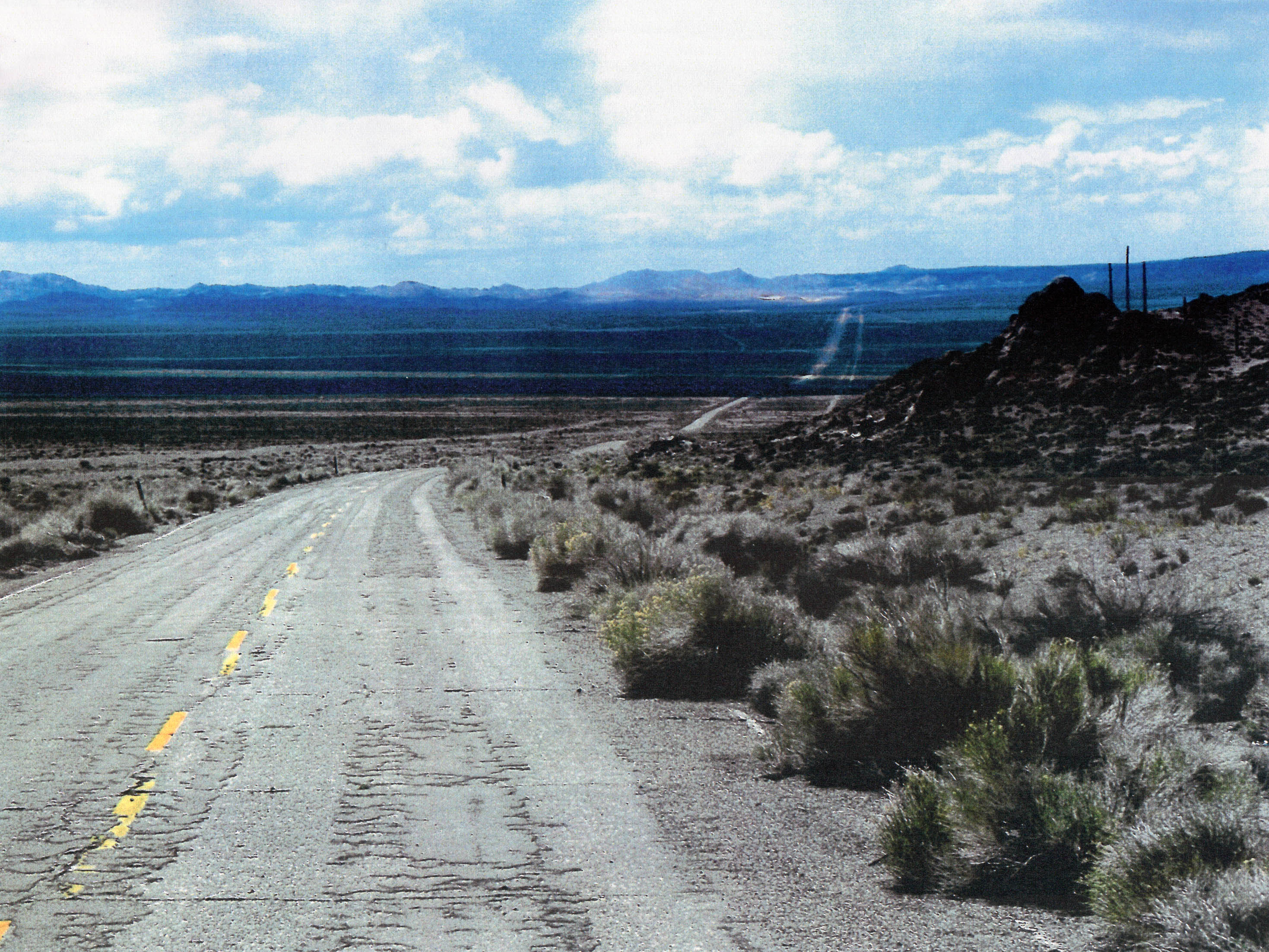
A portion of the Midland Trail that survives near Goldfield, Nevada, in condition similar to what was seen in the 1910s. Photo by Devon Mich’l, 2009.
The Midland Trail was added to the U. S. federal highway system in 1937, with the extension of highway 6 from Denver westward. With only two exceptions (Railroad Valley, and Westgard Pass), the Midland Trail was signed as US-6. It was further given the appellation “Grand Army of the Republic Highway” in 1953.
In 1964, the great decommissioning of US routes in California truncated US-6 to Bishop, but one can find the Midland Trail by taking US-395 south from there, then turning on to California state route 14, which parallels the old road, and then San Fernando Road (old US-6/US-99 multiplex) into Los Angeles.
Highway Signs of the Midland Trail
There were four distinct generations of Midland Trail signs produced. They were all made of porcelain enamel and featured a vertically oriented red, white, and blue design. The signs were manufactured by the California Metal Enameling Company (CAMEO) of Los Angeles, and placed in the field by the Auto Club, who also did the surveying work.
First Generation Signs
| click on each thumbnail to bring up larger images! | ||
 |
 |
 |
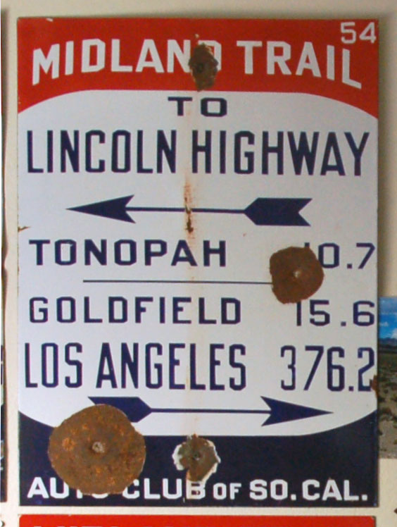
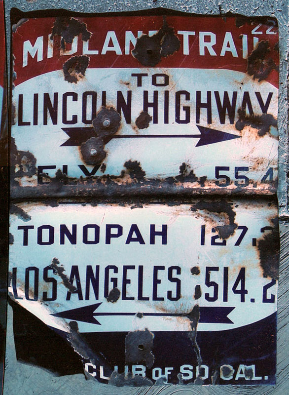
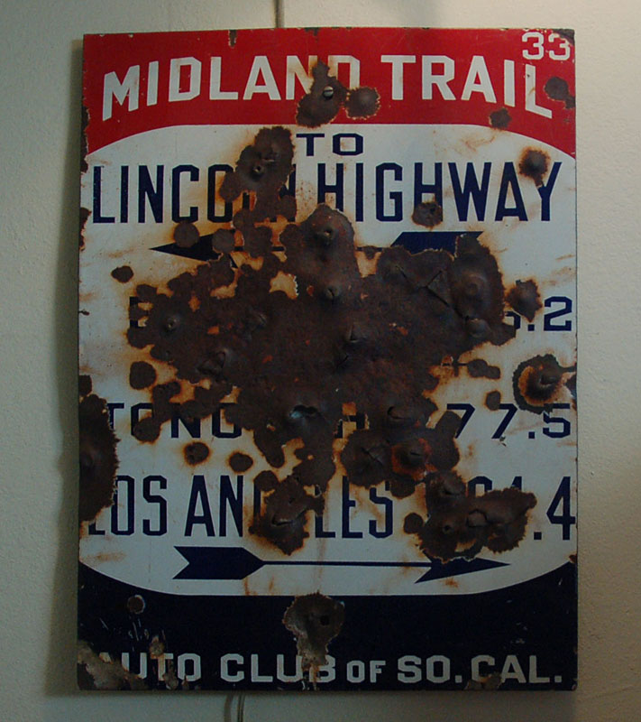
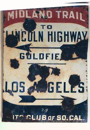
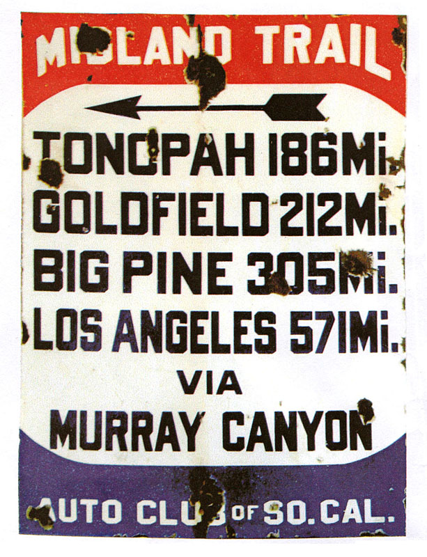
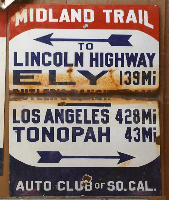
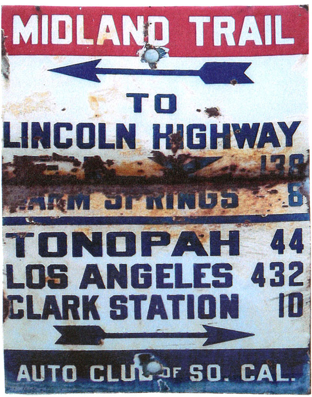
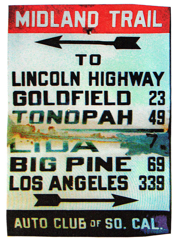
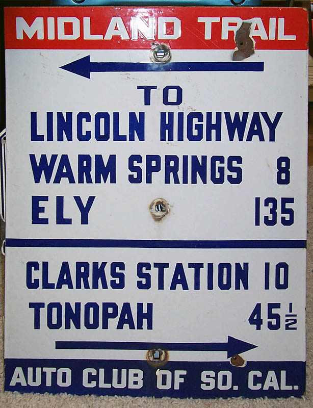
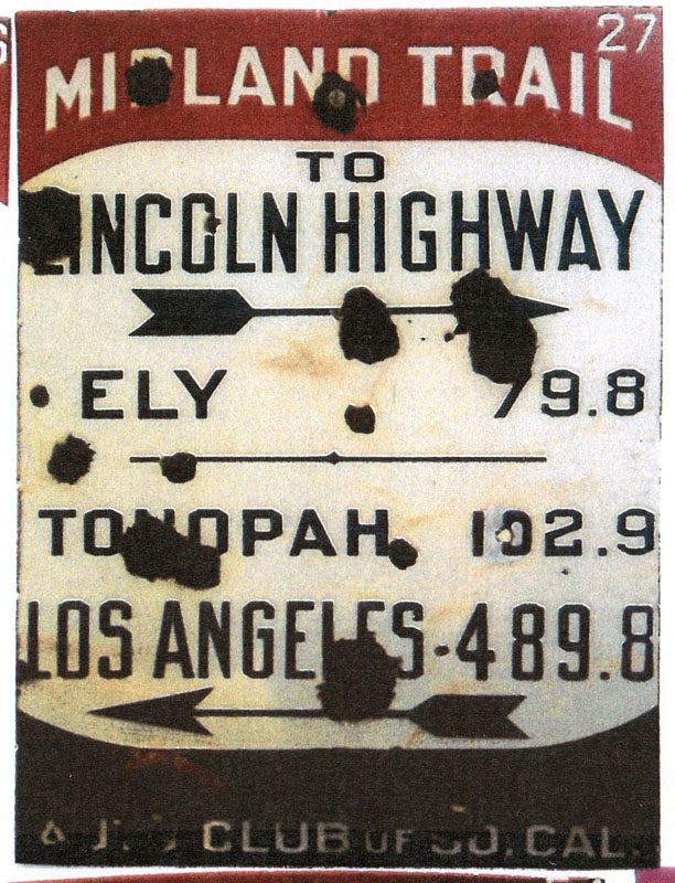
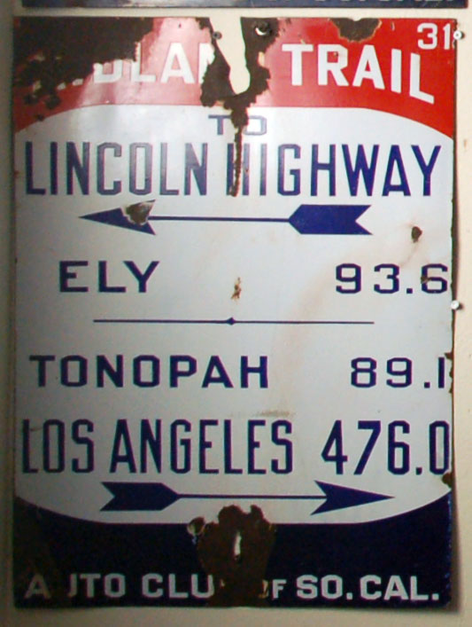
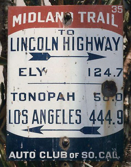
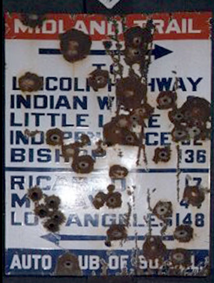
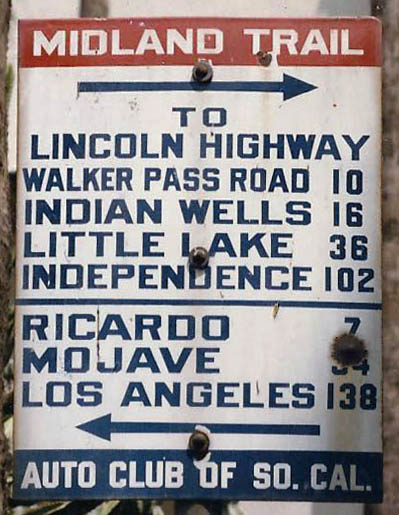
Here are three surviving first-generation signs. They were placed during the initial signing of April, 1915. Each was given an identification number, as seen in the upper right corner. Sign #1 was posted in Ely at the beginning of the trail, and the numbers increased westward. #50 was in Tonopah, #60 in Goldfield, and the state line was somewhere between #69 (Lida) and #80 (Big Pine).
Alas, no state-line sign survives, but if I had to make my guess, I’d say #73.
The first generation can be distinguished by the serial number, and also the mileage in tenths, the feathered arrow, and the arced red and blue top and bottom fields.
As you can see, over the years the signs have put up with uncountable abuses – being folded in half to take up less space in the junkyard, and of course occasionally receiving a face full of 45s.
 |
Some signs were used to identify particular hazards. Here, the center of the trail turned into a mud puddle, and to avoid bogging down and creating an impassable situation, drivers were advised to keep to the right.
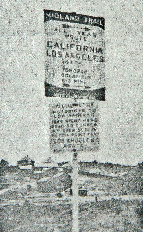 |
Here is what appears to be the very first sign of the trail, placed in Ely. It is a 24×32 inch sign, as opposed to every other one I have seen, which is 18×24.
The legend is a bit hard to read, but here is what we have been able to decipher: all year route to California/Los Angeles: 569.6 via Tonopah, Goldfield, Big Pine.
The number of miles is a conjecture: 569.6 is plausible because it is the total distance from Ely to Los Angeles.
The second sign on the gantry (click the picture to see it) is also an Auto Club of So Cal installation: Special notice: motorists to Los Angeles take right hand road to Copper Mt., then return to this point for Los Angeles route. Perhaps the town of Copper Mountain paid for the publicity!
The photo is from a 1920 Auto Club magazine, provided to me by the Caltrans Library.
 |
One final first-generation sign: this temporary sign has no mileages, and no identification number. It was intended as a temporary placement before a new one could be manufactured with the proper distances.
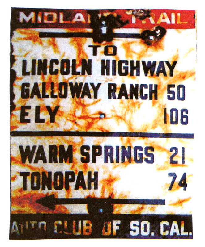
Second Generation Signs
The second generation of signage was placed between 1916 and April, 1917. That is when the US entered World War I, and such trifles as highway signage were put aside until the armistice of November, 1918.
 |
 |
 |
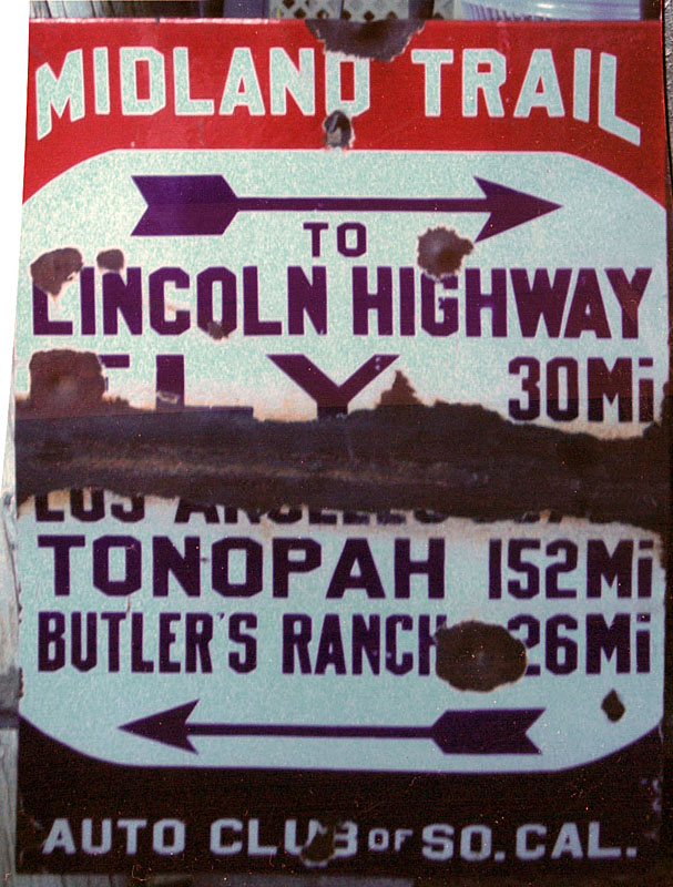
These three signs are of the second generation. The leftmost one is the very first one from Ely, where the Midland Trail diverged from the Lincoln Highway. The arced backgrounds still remain, but are shaped slightly differently, and the font is different as well. This is the only sign set that had “Mi.” after the mileages.
Furthermore, there is no number on the front in the upper right corner. However, these signs were numbered on the back, in a black stamp similar to other Auto Club signs. Numbers for Midland Trail signs were all around 2200, according to Devon.
Third Generation Signs
 |
 |
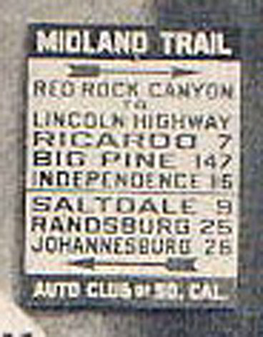 |
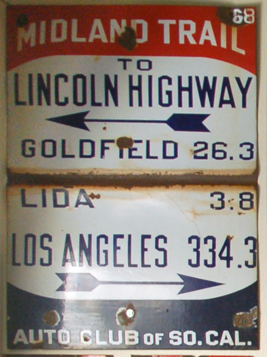
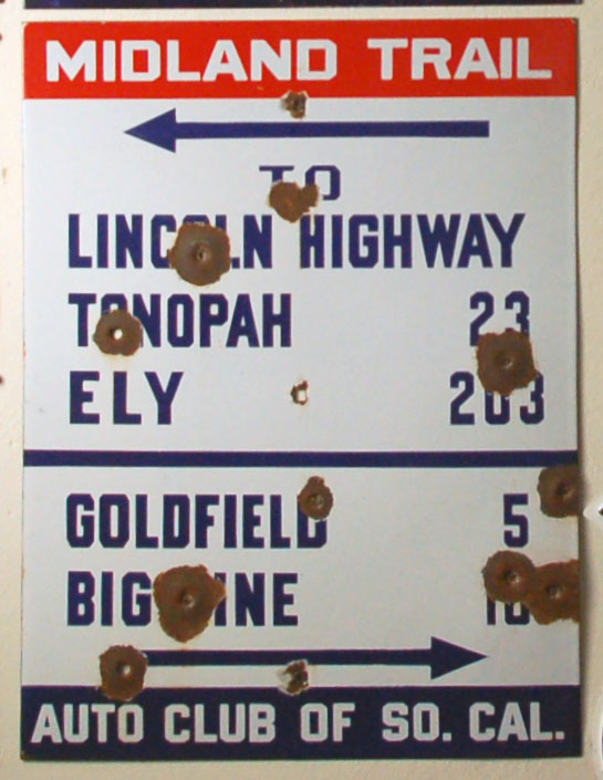
The third generation, posted from November, 1918 (1919, in all practice) to 1921, was the last generation to feature the feathered arrow. The top and bottom fields were no longer arced, and the dividing line between directions was made to stretch all the way across the sign.
The first two signs are from Nevada, and the last one is from California. The photo appeared originally in a 1919 Auto Club publication.
The third generation signs had no number on the back.
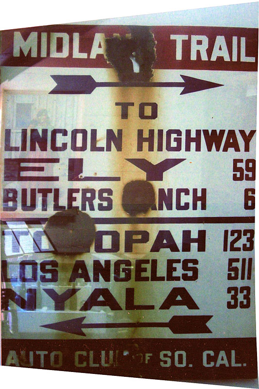
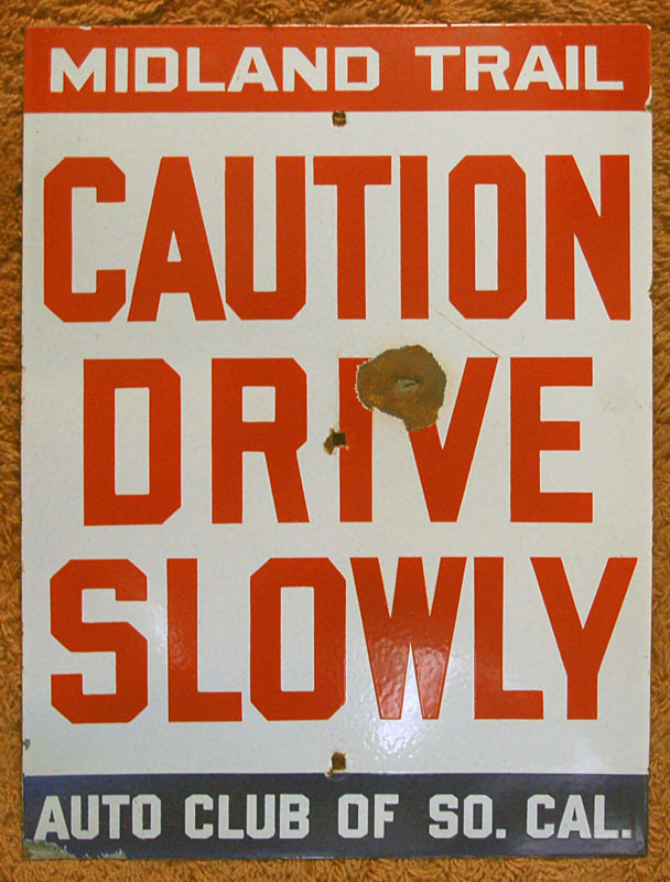
Fourth Generation Signs
 |
 |
 |
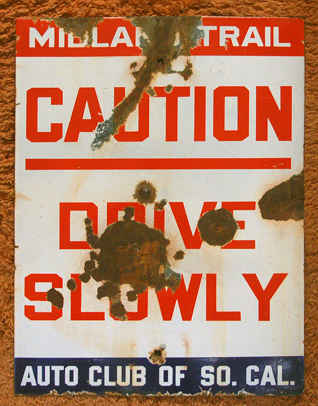
The fourth generation reflected the general Auto Club practice, starting in 1921, to change from feathered to block arrows. Furthermore, signs that did not feature destinations were added to the repertoire: the middle photo says, simply “CAUTION DRIVE SLOWLY” and could be placed anywhere along the route to warn of a particular hazard.
For stability, a third mounting hole was added as well. Furthermore, the signs in Nevada no longer featured Los Angeles as a destination. Finally, the fourth-generation signs did have a standard black stamped number on the back.
The fourth-generation signs were placed between 1921 and 1923. It is unknown how the route was signed after 1923 and before February 1929, when the Auto Club started using the black and white rectangle format of guide signs universally, to replace the diamonds and the red, white and blue rectangles.
Later Signs
Starting in February, 1929, the Auto Clubs consolidated all the sign styles into this format.
 |
This sign is somewhat larger than the previous ones, at 36 by 24 inches. The names of the old trails are no longer identified on this set of signage.
The signs do have numbers on the back. Starting in 1934, those signs that were posted on California state highways (including most of the Midland Trail in California, which was state route 7 before being renumbered to U. S. highway 6) featured a standard California code, identifying the date, the district, and the serial number of the sign. A typical code would be “A7D40”, where A is the year (1934 is A, 1935 is B, etc), 7 is District 7 (Los Angeles and Ventura counties), D stands for “directional sign” or “distance sign”, and 40 is the serial number. Nevada signs continued to have just a simple serial number.
The Midland Trail Today
In many cases, the Midland Trail was upgraded continuously to better standards, and exists as two-lane roads in California and Nevada. For example, Historic US-6 through Rosamond, Lancaster, and Palmdale, California is the Midland Trail, as is state route 168 over Westgard Pass.
US-95 heading south out of Tonopah. This alignment was bypassed only in the 1980s by a new four-lane road. This section of 95 was built directly on top of the 1860s unimproved road that became the Midland Trail. Photo by Devon Mich’l, 2009.
Further Information
For more information on the Midland Trail, to contribute any knowledge and pictures of signage, or if you’re interested in trading Midland Trail and other old highway signs, please contact me at jake@aaroads.com, or Devon directly at 702-296-9393.
Gallery
Some more photos of the older Midland Trail signs.
| first generation | ||
 |
 |
 |
| third generation | ||
 |
||
| fourth generation | |||
 |
 |
 |
 |

This is great! Looking forward to more in the series.
they will come :) look for a set of signage histories for all 50 states, and special articles like this one!
I wonder if the line above Tonopah in that first generation Ely sign is something like “569.6”. I think I can make out 5 and 6, but beyond that I can only guess. What looks like an extra character doesn’t help.
Nice work with this set! Keep it up.
that is very plausible! 569.6 is the total mileage from Ely to Los Angeles.
I had the sign as a first-generation, but have just edited the post to move it to second-generation, as the font is clearly second-generation and the only way the 569.6 mileage makes any sense is if it says “Mi”. (Without “Mi” it would be mis-centered.)
as for why it looks like there is a number in the upper right corner? I do not know if that is a second-generation sign with a number, or if it’s just dust on the photo negative.
okay, I actually moved the 24×32 sign to its own category because it seems to share features of both the first and second generation styles!
bah, and I moved it back to first generation (where it originally sat), as upon closer inspection, the shape of the arc matches, as does the lettering in “Midland Trail”, and several other first-generation signs use that font too.
the 569.6 is indeed, apparently, miscentered. Looks like they approximately left-aligned 569.6, Tonopah, Goldfield, and Big Pine in the same block.
I’ve seen “first state” metal sign #88, and according to my notes the legend read arrow right – Big Pine 1.6, then arrow left Independence – 26.7, Los Angeles 265.9.
Road sign intelligence has revealed the existence of Midland Trail “first state” metal porcelain enamel guide sign # 50. Unfortunately no photos at present time, but according to reliable sources the legend reads – arrow left Tonopah 1.7, – then arrow right Goldfield 24.6, Los Angeles 385.2. Aforementioned guide sign is reported to be in fair condition, having sustained protracted firearm causational distress.
what do you mean by “first state”, Shemp?
“first state” = loosely, “first generation” in your parlance. By the way there may have been pre “first generation” Midland Trail guide signs made out of wood or painted metal, posted by various “good road associations” or AAA.
Also inter-generational guide signs may be evidenced by various thicknesses of arrow shafts, points, and corresponding tail feathers in the c 1917 to 1921 time frame.
“Fourth State” or “Fourth Generation” solid arrow guide signs will have subtle diiferences also, mostly in the size of the lettering and spacing, between the c 1922 and 1927 time frame.
From what i understand sign crews were instructed to fold the decommisioned guide signs in half to prevent future misuse. Other times they would bury them, or throw them into abandoned mine shafts.
great information; thank you for sharing! any chance you can dig up a photo of #50, or any of the painted or wooden markers?
and yes, I do see the variations in the fourth generation signs. This is also a feature of the diamond guide signs of the ACSC, with subtle differences in fonts and whatnot.
the diamonds were used as late as Feb 1929, when they changed over to the white rectangles. were the red, white, and blue signs used that late too? I know outside of California, the Auto Club kept putting up diamonds as late as the 30s (I have a 1934 photo from Mexico) and I think the red top National Old Trails Road signs persisted into the 30s as well in Arizona and further east.
I’ve never seen any evidence indicating red white and blue signs were posted after 1928. I would think that with the uniform sign business and the advent of numbered highways the last thing the ACSC would want to do, would be to confuse the motorist with a multitude of different names or numbers for the same road. There may have been some overlapping in the transition to numbered routes though so you’ll see (as in some of your photos) for a while, for example, a numbered route shield and a national old trails marker on the same post. Personally i think most of the red white and blue signs had been removed or otherwise rendered obsolete by the late ’30s.
yep, there definitely exists the pairing of a 66 shield and an Old Trails diamond. I would imagine that combination to date to 1928 quite exactly; that was the first year of route shields and one of the last years for the diamonds.
what a great job.
thanks so much
bruce
glad you like it Bruce :)
there are a lot more pictures, and info coming soon…real cool stuff. Devon
Where did you come up with this info?
“It became the first road in Nevada to be federally funded.” I would like to use it, but need to verify it first, good work on the signs and the site. Enjoying it.
On seeing the signs, I enjoyed placing their locations on my 1936 Nevada road map.Hard to believe the cutoff to Los Angeles or Washington D.C. went through Nyala and Lida Ha!
Great work Devon, I enjoyed.
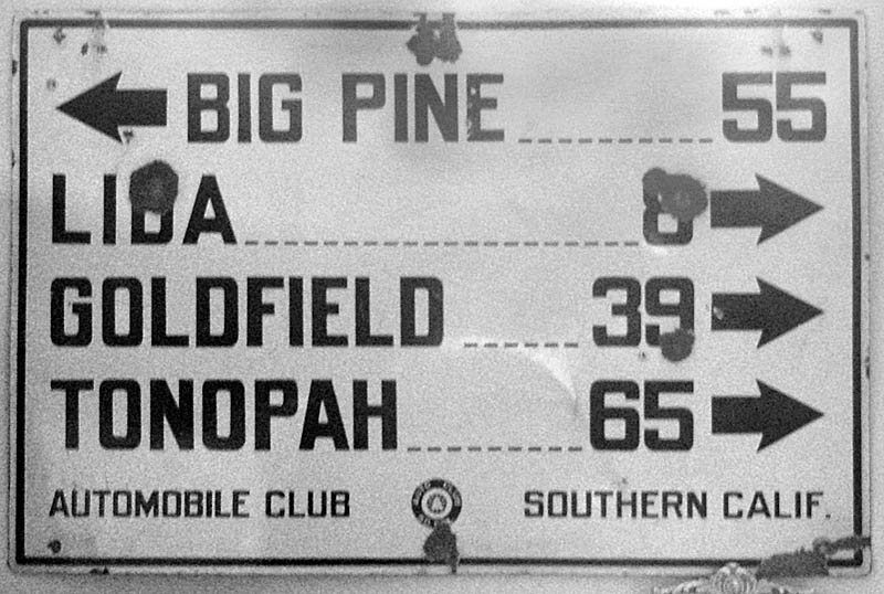
Do all the towns on the signs lie along the Midland Trail? I am confused by the photo in the third generation sign section; the one with Saltdale, Randsburg, and Johannesburg. Those towns are as many miles as indicated East of present-day California State Route 14 along Redrock-Randsburg Road. It would have to have been near the junction of those two roads. It makes no mention of Los Angeles since it is in neither direction that the sign points. If I was going to Los Angeles and I came from Big Pine, I would likely go the wrong way unless there was another sign right next to it.
I read elsewhere that some “fake” signs were made to direct motorists to communities off the route to boost local businesses; I am convinced that what this oddball sign was.
absolutely killer Midland Trail signs (and research)Jake, I had no idea there were so many survivors. Love the first generation with feathers and numbers, about as great a road sign as there could be….be awesome to get one someday….luckily we have Rocky Mtn Motorists signs here in Colorado to satisfy the early sign enthusiast.
Nice work by you and Devon, thank you
We enjoyed reading your blog. We were out on a Sunday ride today and found a second generation sign from the Midland Trail. It was bent in half and folded back on the bottom left hand corner. It has seven directions: Lincoln Highway; Lida; Goldfield; Tonopah; Big Pine; Independence; and Los Angeles. We cleaned it up but was wondering if we should straighten it out, we don’t want to chip the enamel. I would also like to mention there are no bullet holes in it. By chance do you know why so many of the second generation signs were bend in half?
Thank you.
I have more info and picts. please contact me anytime regarding old road signs….midland trail, old national trails road, licoln hwy. victory hwy in Nevada and any so.cal. auto club signs DeVon 702 296 9393
Thanks for a truly great informational web-site. I don’t know if this will interest you, but there is an original Auto Club of Southern California diamond mileage sign for sale on on Ebay right now. The mileages are to small towns outside Bakersfield. They want a truly outrageous price for the sign. I made what I thought was a respectable offer for the sign, but they more or less laughed at me!
Getting to the main point of my e-mail, what can you tell me about a type of sign known as a “Goodrich Guide Post?” How common were these in the days before the first Auto Club signs were put up?
Also, somewhere in the area of Globe, Arizona, there is a directional sign that pre-dates the automobile. Made of cast iron, it appeared to have been produced in a local mine around 1880 [mining was a big industry in Globe even then]. This sign gave mileages to a local ranch, and to a town that no longer exists. As a college student in the early 1980’s, I saw the sign in a Globe antique store. Years later, after I finished college, I attempted to track the sign down. Unfortunately, the owner of the antique store had died, and the building had been torn down.
Anyway, thank you again for the great information.
Chris Ackerley
I just purchased a first series Midland Trails sign # 64 yesterday pretty nice shape