Philadelphia, PA

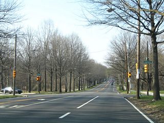
Broad Street north from City Hall

10th and Race Streets - Chinatown

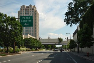
Delaware Expressway - Penns Landing
Overview
Home of Independence Hall and the Liberty Bell, the City of Brotherly Love boasts over 1.5 million residents. Philadelphia points of interest include the Ben Franklin Institute, the Philadelphia Museum of Art, Fairmont Park, Penns Landing, the University of Pennsylvania, etc. The city is also well known for its role in the Rocky movie series.
Situated along the Delaware River, Philadelphia was formerly an industrial center, with its riverfront populated with a variety of industry. Until 1995, the Philadelphia Navy Yard operated along the Delaware by the mouth of the Schuylkill River as well. While shipping and port operations remain stalwart in South Philadelphia, further north redevelopment efforts have transitioned large tracts into retail and other non-industrial developments. This includes stretches along Christopher Columbus Boulevard and Delaware Avenue toward Northeast Philadelphia.
Interstate 95, the Schuylkill Expressway and Roosevelt Boulevard are the main arteries serving the city of Philadelphia. Traffic woes are a routinely occurrence, and expansion and modernization of these corridors is often costly and impractical due to limited right of way or environmental concerns. Several canceled highways can be traced through the history of Philadelphia as well, including the Pulaski Expressway through the Frankford neighborhood, the South Street Expressway and the Crosstown Expressway through Elmwood and Kingsessing communities among others.
Routes
 Schuylkill Expressway
Interstate 76 straddles the west banks of the Schuylkill River along a narrow right of way. As such, the Schuylkill Expressway is generally six lanes in width, with auxiliary lanes added in locations. The winding nature of the freeway includes the locally infamous "Conshohocken Curve." A routine site for congestion and traffic incidents, this section of roadway lies east of Interstate 476 (Mid-County Expressway) and across the river from the borough of Conshohocken.
The Schuylkill Expressway was the first freeway constructed within Philadelphia, with work commencing in 1949. Extending southeast from the Valley Forge Interchange from the Pennsylvania Turnpike, the expressway opened in Montgomery County on September 1, 1954. The route was designated as PA 43.1
The 1956 Federal Highway Act provided needed funding for completion of the Schuylkill Expressway. With it came several Interstate numbering proposals, with 80S ultimately selected in November 1958 for the route between the PA Turnpike and the Vine Street Expressway, and 680 for the southern loop to the Walt Whitman Bridge. The freeway was completed on June 30, 1959, with the portion west of Center City opened at that time.1
Interstate 80S was decommissioned through Philadelphia in 1964, with the Schuylkill Expressway between Valley Forge and the Vine Street Expressway renumbered as I-76. I-76 remained planned along the Vine Street Expressway east to the Ben Franklin Bridge and south through Camden, New Jersey, with I-680 along the southern most Schuylkill Expressway changed to Interstate 676.
With completion of the Vine Street Expressway uncertain, a final numbering change occurred in 1973 as I-76 and I-676 switched places. Using the Walt Whitman Bridge, this provided a continuous route for I-76 south to Interstate 295 in South Jersey.
 Delaware Expressway
Interstate 95 travels the height of Philadelphia, from Philadelphia International Airport (PHL) and the Girard Point Bridge to the southeast, to Holmesburg and Torresdale to the northeast. Named the Delaware Expressway throughout the city, the freeway generally follows the course of the Delaware River by port facilities in South Philadelphia, between Society Hill and Penns Landing east of Center City, and through a mix of dense residential neighborhoods and industrial areas through Northeast Philadelphia. The urban freeway varies between six and eight overall lanes, with the ongoing 95 Revive project expanding portions of the route north from the Vine Street Expressway. I-95 drops below grade between the Walt Whitman and Ben Franklin Bridges, and elevates along a series of viaducts between Kensington and Bridesburg. Beyond the north city line into Bucks County, I-95 transitions to a six lane suburban freeway through to the PA Turnpike interchange with I-276.
The first section of the Delaware Expressway opened to traffic in 1962 following three years of construction. It extended south from PA 413 in Bucks County to PA 73 (Cottman Avenue) in Northeast Philadelphia. The route was completed south to Girard Avenue at Kensington in 1969.2
Work on Interstate 95 north from Delaware County was completed in 1976 with the opening of the Girard Point Bridge across the Schuylkill River, and overall freeway from Enterprise Avenue and I-76 (Schuylkill Expressway). The gap between the Walt Whitman Bridge and Kensington was controversial, due earlier proposals for an elevated roadway along the Delaware River. Minimizing the visual separation from Downtown and the riverfront, the design changed to a below-grade freeway with a lid at Pine Street. Work finally got underway in 1972, with completion in September 1979.2
The last portion of Interstate 95 built in Pennsylvania was the four mile alignment by Philadelphia International Airport (PHL). Delayed due to funding deficits and environmental concerns on how to drive piles without contaminating a freshwater supply basin from an adjacent sewage lagoon, this section took nearly ten years to complete. It finally opened on December 15, 1985 at a cost of $191 million.2
 Pennsylvania Turnpike
Interstate 276 overlays the Pennsylvania Turnpike east from the split with I-76 at the Valley Forge Interchange. The route formerly extended east to the Delaware River Turnpike Toll Bridge and New Jersey state line near Bristol. Sign changes in 2018 realigned Interstate 95 from north of Bristol to Trenton, New Jersey, to instead follow the Pennsylvania Turnpike, and the adjacent Pearl Harbor Memorial Extension of the NJ Turnpike, east from Bucks County to Mansfield township. I-276 was subsequently dropped from the easternmost extent of the PA Turnpike to end at the new interchange with Interstate 95, and the western extension of I-295 from Lawrenceville, New Jersey.
The Delaware River Extension of the Pennsylvania Turnpike was financed in 1951 and construction starting in 1952. The toll road opened east from Valley Forge to then-U.S. 309 in Fort Washington on August 21, 1954. The ensuing stretch east to U.S. 13 in Bristol Township was finished on October 16, 1954. The steel arch bridge across the Delaware River completed the link with the NJ Turnpike. It opened on May 23, 1956.3
The 1956 Federal Highway Act allowed for the addition of the Delaware River Extension into the new Interstate Highway system. With the Pennsylvania Turnpike mainline west from Valley Forge designated as Interstate 80S in 1958, I-280 was selected for the Delaware River Extension. I-280 changed to I-276 in 1964, coinciding with the renumbering of I-80S to I-76.3
 Mid-County Expressway / PA Turnpike Northeastern Extension
Known locally as the Blue Route, the 21 mile long Mid-County Expressway winds through suburban areas of Delaware and Montgomery Counties. Originally planned as an eight lane freeway, the commuter freeway is four lanes wide from I-95 in Chester north to PA 3 near Swarthmore, and six lanes for the remainder of the route north to Broomall, Radnor, West Conshohocken and Plymouth Meeting.
Initial plans for a Mid-County Expressway (Interstate 480) west of Philadelphia arose in 1960. Four alignments were selected for public review in 1961. With some opposition, the "blue route" was chosen as the preferred alignment. Before any section was ready for traffic, the Mid-County Expressway was renumbered from I-480 to I-476 in 1964. Work was slow to follow, with the initial 2.5 mile section opened north from Darby Road to PA 320 in Radnor township in 1969. Passing of the National Environmental Policy Act of 1969 led to law suits requiring additional environmental studies. The resulting delays pushed back progress on the Mid-County Expressway, with only three miles opened to traffic from the Schuylkill Expressway north to Chemical Road.4
Nine miles of roadway were finished in 1978, with construction on the remaining sections resuming in 1985 at Ridley Township. The Mid-County Expressway opened south to Chester on December 19, 1991. Upon completion of Interstate 476, drivers flocked to the route, alleviating congestion on parallel Pennsylvania 320, and U.S. 202 further west. Opening of the direct connection with the Pennsylvania Turnpike (I-276) at the Northeastern Extension followed in 1992. With a seamless link north from the Mid-County Expressway to Allentown, Scranton and Upstate New York, the Northeastern Extension was renumbered as an extension of Interstate 476 in 1996.4
 Vine Street Expressway
Interstate 676 follows the Vine Street Expressway to the north of Center City Philadelphia between Logan Square, Franklin Town and Chinatown. The four to six lane freeway travels below grade from the Schuylkill River by Fairmount Park to Benjamin Franklin Parkway and North 10th Street. East from 10th Street, the freeway splits with surface ramps linking I-676/U.S. 30 with the Ben Franklin Bridge at 5th Street. The easternmost extent of the Vine Street Expressway provides a direct connection with Interstate 95 (Delaware Expressway) above Callowhill Street.
Included in the Interstate system, work commenced on the Vine Street Expressway east from the Schuylkill Expressway to 18th Street in 1957. The spur opened on June 30, 1959. It was designated in 1958 as a part of Interstate 80S, which followed the Schuylkill Expressway northwest from Mantua to Valley Forge, and then I-76 in 1964. Renumbered again in 1973 as I-676, construction on the Vine Street Expressway east from 18th Street did not resume until 1986. This followed revisions to the design, including the elimination of direct connections between the freeway and Ben Franklin Bridge, and additional environmental studies. Interstate 676 opened east to the Breezewood style connection with the Ben Franklin Bridge in January 1991, with the high speed exchange at I-95 finished that summer.5
 Interstate 295
Interstate 295 parallels the New Jersey Turnpike from rural Salem County northward through older suburbs including Bellmawr, Cherry Hill and Mount Laurel along a 71 mile course to Lawrenceville township outside Trenton. The route was lengthened southwest to Bucks County, Pennsylvania in 2018 with the completion of the I-95/PA Turnpike Interchange. Sign changes extending I-295 west over what was I-95 from U.S. 1 to Ewing, New Jersey, and southwest to I-95 and I-276 in Bristol township commenced by January 2018.
 Crosstown Expressway
The planned route for Interstate 695 followed the Cobbs Creek Expressway north from Interstate 95 near Philadelphia International Airport (PHL) to Interstate 76 (Schuylkill Expressway) at the Grays Ferry community. The eastern extent of I-695 was proposed along the Crosstown Expressway along Lombard and South Streets, extending east from the Schuylkill Expressway to I-95 (Delaware Expressway) by Queens Village. The Federal Bureau of Public Roads approved the route as an Interstate Highway in 1957, and it was formally designated as I-695 in 1959.6
The Vine Street Expressway was the northern part of a planned system of expressways encircling Center City Philadelphia. The inner loop included the Schuylkill Expressway (I-76), the Delaware Expressway (I-95) and the unbuilt Crosstown Expressway (I-695). Funding for the below-grade freeway was secured in 1967, leading to increased community opposition. A year later, approval for construction of the directional T interchange with the Delaware Expressway advanced.6
With increasing controversy for the eight-lane freeway, plans for the route shifted in 1972 to an covered route with space above redeveloped for new apartments and office space. Neighborhood leaders who stayed in the path of the planned 2.8-mile long freeway however continued to campaign against the Crosstown Expressway, ultimately leading to the cancellation of the freeway plan in 1973.6 The only remnant of that plan are ramps between I-95 and Columbus Avenue.7
The Cobbs Creek Expressway was outlined along a 6.9-mile route north from I-95 near PA 291 to I-76 at Grays Ferry Road. The freeway included a link with the proposed Lansdowne Expressway leading west to U.S. 1. Funding for this leg of I-695 was incorporated into the Pennsylvania's six-year construction program in 1967. However by 1969, the state dropped and diverted funds to other Interstate projects.
Despite efforts to revive the Cobbs Creek Expressway to improve access between the city and PHL Airport, and with Mayoral support, plans for the freeway were dropped by the Philadelphia City Planning Commission in 1974. The Federal Highway Administration (FHWA) approved the formal withdraw of I-695 from the Interstate system that year.7
With the old sequential exit numbering system, Interstate 695 was the missing Exit 13 on northbound Interstate 95.
 Interstate 895 - Decommissioned
The idea for a new bridge across the Delaware River between Burlington, New Jersey and Bristol, Pennsylvania Bridge arose in 1963 as part of a Delaware River Port Authority (DRPA) report. The span was eventually incorporated into a proposed expressway linking I-295 near Mount Holly, New Jersey with Interstate 95 in Bucks County. The Federal Bureau of Public Roads added the route to the Interstate System in 1968, with it numbered as Interstate 895.
Proposals for the 6.8 mile route route of I-895 called for a the six-lane freeway to vary with sections built below grade, built upon earthen embankment, or elevated along viaduct. New Jersey Route 72 would have extended the freeway from I-295 to the NJ Turnpike and points east. The red corridor through Burlington and Bristol was selected by the FHWA for I-895 in 1973.
A bill authorized work on the New Jersey portion of the route in 1975. With an estimated cost of $84 million, completion of I-895 was scheduled for 1978. However due to increasing costs and pressure to divert funds elsewhere, $180 million in funds allocated for Interstate 895 were reallocated in 1981 to mass transit and other highway projects.8
 Roosevelt Boulevard / Expressway
U.S. 1 separates Overbrook and Wynnefield in west Philadelphia from Montgomery County along City Avenue. The slow moving arterial leads the US route northeast from Cobbs Creek Park to the Schuylkill Expressway across from East Falls and Fairmount Park. U.S. 1 combines with I-76 to connect with the Roosevelt Expressway. Completed in 1961,11 the 3.5 mile long freeway arcs east between Germantown and Nicetown to U.S. 13 at Hunting Park.
The remainder of U.S. 1 through Philadelphia navigates along Roosevelt Boulevard, a unique arterial comprises of four roadways. The outer two-lane roadways connect with all local and intersecting streets, while the inner three-lane roadways function more like a controlled access expressway. Slip ramps provide ingress and egress points between the respective roadways. Roosevelt Boulevard otherwise doubles as both U.S. 1/13 eastward through the Logan, Feltonville and Frankford communities to the couplet of Robbins and Levick Streets. U.S. 1 turns more northward from the split with U.S. 13 there between Mayfair, Rhawnhurst, Pennypack and Bustleton through Northeast Philadelphia. PA 63 accompanies the route from Red Lion Road to the Woohaven Road freeway at Normandy. The four-roadway setup along Roosevelt Boulevard concludes ahead of the Bucks County line by Benjamin Rush State Park. Beyond the city and PA 132, U.S. 1 transitions into a freeway eastward to Langhorne, Morrisville and Trenton, New Jersey.
 Baltimore Av / 38th St / 33rd St / Hunting Park Av / Frankford Av
U.S. 13 travels a convoluted surface route throughout Philadelphia. Entering the city from the borough of Yeadon, U.S. 13 follows Baltimore Avenue through the Cobbs Creek and Garden Court communities to 38th Street north through University City. Powelton Avenue dog legs the route east from 38th Street to a one way couplet along 33rd / 34th Streets through Mantua. Passing by the Philadelphia Zoo, U.S. 13 combines with U.S. 30 to cross the Schuylkill River.
33rd Street resumes north from U.S. 30, taking U.S. 13 along Fairmount Park and the Strawberry Mansion community. The route shifts onto Ridge Avenue and then Hunting Park Avenue as it arcs northeast to Nicetown and Tioga. Through Hunting Park, U.S. 13 merges with U.S. 1 (Roosevelt Boulevard) via a wye interchange. The two overlap 4.3 miles east along Roosevelt Boulevard to Mayfair.
U.S. 13 angles southeast from U.S. 1 along the couplet of Robbins Street south and Levick Street north to Frankford Avenue. Frankford Avenue leads U.S. 13 east to the Tacony, Holmesburg, and Torresdale communities in Northeast Philadelphia. Crossing Poquessing Creek, U.S. 13 exits Philadelphia through southern Bensalem Township in Bucks County.
Paralleling Interstate 95 through Andalusia, Cornwells Heights and Bridgewater, U.S. 13 continues northeast to the borough of Bristol. North of the Pennsylvania Turnpike (I-95) and Tullytown, U.S. 13 upgrades to a freeway through to Fallingston and its northern terminus at U.S. 1 outside Morrisville.
 Woodhaven Road
Woodhaven Road is a 3.7 mile freeway spurring northwest from Interstate 95 in Bensalem Township to Normandy in Northeast Philadelphia. PA 63 follows the highway from Interstate 95 to U.S. 1 (Roosevelt Boulevard) as part of its route northwest to Bryn Athyn in Montgomery County. The four lane freeway utilizes a frontage road system to connect surface streets in the Millbrook and Parkwood communities of Philadelphia.
Woodhaven Road was constructed in 1962, with the freeway open from I-95 to U.S. 13 in 1963, and northward to U.S. 1 in 1966.8 The freeway extends a short distance beyond an incomplete cloverleaf interchange with Roosevelt Boulevard to Evans Street. Roadway stubs, built for the unconstructed Woodhaven Road Extension, provide access to local businesses.
The Federal Highway Administration (FHWA) approved the Woodhaven Road Extension in 1968, and land acquisition moved forward on the 2.3 mile long freeway. Mounting opposition both from homeowners in Lower Moreland Township, coupled with rising costs led to cancellation of work on the highway by the late 1970s. Subsequently, with stricter environmental studies required, the FHWA rejected the original studies for the route, requiring PennDOT to conduct a new environmental impact statement for the project.8
Further development along the corridor eventually hampered construction plans. Despite approval for work on a 1.5 mile long extension to Bustleton Avenue in 1988, area residents objected to the project, ultimately shelving it.8
 Betsy Ross Bridge
Built between 1969 and 1973, and opened in April 30, 1976, the Betsy Ross Bridge links Interstate 95 and the Bridesburg community of Philadelphia with U.S. 130 (Crescent Boulevard) in Pennsauken Township. The continuous truss bridge bridge is part of unsigned Pennsylvania Route 90 and New Jersey Route 90. The multi state route extends east from Morrisville as freeway to Route 73 in Burlington County.
The multi level interchange with I-95 was constructed with provisions for the planned Tacony Expressway. A 1958 proposal for the Tacony Expressway outlined a route along Tacony Creek northwest from the Delaware Expressway to Juniata Park and U.S. 1 (Roosevelt Boulevard) at Tacony Creek Park. With an eastward adjustment along Adams Avenue, the six mile route was included in the Philadelphia City Planning Commission expressway plan in 1966. Completion was estimated for 1971.9
Renamed the Pulaski Expressway in 1969, further developments in the proposed freeway resulted in realignments to avoid Adams Avenue and Juniata Golf Course. Stricter environmental regulation led to further adjustments in 1971. A shortened route was studied, with construction slated to run from 1978 to 1981. PennDOT stopping funding for highway projects in 1977, which ultimately led to the cancellation of the Pulaski Expressway.9
Lengthening of the New Jersey 90 freeway southeast from U.S. 130 started with work underway in March 1986. The 0.8-mile, mostly elevated extension, was completed on October 25, 1988. 1964 proposals for Route 90 continued the freeway south to I-295 and the New Jersey Turnpike. A 6.3-mile long route was scheduled for completion in 1975. Another plan called for the state route to travel 10.2 miles south through Mount Laurel township to Berlin. Due to costs and potential impacts to Pennsauken Creek, plans for the Route 90 extension was eventually dropped by 1980.10
 Batram Av / Penrose Av / 26th St
Pennsylvania Route 291 connects I-76 (Schuylkill Expressway) with Interstate 95 and Philadelphia International Airport (PHL) via the George Platt Bridge over the Schuylkill River. The state route follows Penrose Avenue northeast to Moyamensing Avenue and Oregon Avenue to PA 611 (Broad Street) in South Philadelphia. Until 1954, the state route extended north along Broad Street in South Philadelphia to City Hall and PA 3. The route was truncated to I-76 in 1987.12
 Broad St / Old York Rd
Pennsylvania Route 611 originates at Interstate 95 by Roosevelt Park and the Philadelphia Naval Business Center in South Philadelphia. The state route overlays almost all of Broad Street, one of the principle urban arterials through Philadelphia. The six to eight lane urban arterial extends from City Hall in Downtown to North Philadelphia, Fairhill, Tioga, Logan and Fern Rock. The state route branches east from Broad Street onto Old York Road just south of the Montgomery County line and Cheltenham township.
Prior to 1972, PA 611 was U.S. 611, an intrastate route linking Philadelphia with Scranton. U.S. 611 began at City Hall and traveled north along Broad Street; Broad Street south from PA 3 (Market Street / JFK Boulevard) was designated as PA 291. This changed in 1987 with PA 611 overtaking PA 291 south to I-95 at the Girard Point Bridge.13