
Savannah is one of the oldest cities in the Southeastern United States with a rich history. Boasting over 1,100 historical buildings, the seat of Chatham County lies along the Savannah River within the Gold Coast region of Georgia. With an economic base in industry, tourism, shipping and the Port of Savannah, Savannah is the economic center of southern Georgia. Profiled here are the important roads serving the metropolitan area including freeways, arterials and numbered routes.
Savannah was discovered by English General James Edward Oglethorpe in 1733. Oglethorpe landed his craft along the Savannah River in February of that year and claimed the land as England’s 13th colony. He named the land Georgia after King George II of England.
Savannah was the first city established in Georgia. Oglethorpe planned it with a grid of wide streets complimented by 24 public squares and parks. The squares and other public land would act as meeting places for residents and merchants.
45 years later Savannah was seized by the British during the American Revolution. The occupancy lasted four years, between 1778 and 1782, withstanding a failed liberation attempt by American and French forces in 1779. After the war’s end, Savannah prospered as an agricultural center with rice and cotton representing the staple crops. Reflecting the economic prominence of area residents as farming increased, beautiful Victorian homes rose across the city. Trade bloomed as well with the invention of the cotton gin, further anchoring Savannah’s port as a commercial hub.
Misfortunes could not avoided in Savannah however. Major fires leveled portions of the city in 1796 and 1820, and Savannah again faced challenges in the years leading up to the Civil War. Trade blockades and other setbacks eventually sent the city economy into a downward spiral. When the Civil War finally broke out, nearby Fort Pulaski was captured in 1862 and by 1864 General William Sherman, and his conquering rampage of destruction, arrived in Savannah. Residents of the city evacuated before his appearance, sparing Savannah the fiery fate that had previously leveled Atlanta. Sherman instead fell in love with the city and spared it any harm. He presented it to President Abraham Lincoln as a gift on December 22, 1864, heralding the end of the Civil War for Savannah.
A slow rebuilding effort and resettling of Savannah ensued in the years following the Civil War. Cotton again emerged as the agricultural staple for the city and the port thrived with exports of rosin and lumber. African American slaves freed by the Civil War also settled in the city, establishing churches, schools and neighborhoods. Things improved through to World War I and the Great Depression with its economic hardship.
After World War II, Savannah reinvented itself as a historical city while shunning many urban renewal concepts. Thanks to the efforts of the Historic Savannah Foundation and other community groups, the modernistic architectural movement prevalent among many American cities at the time never took its full course in Savannah. The foundation aided Savannah’s Historic District in obtaining National Historic Landmark status in 1966.
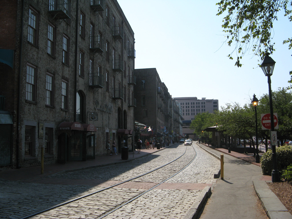
Nowadays Savannah continues to capitalize on its history in the form of tourism. People visit the city from around the world to see Savannah’s architecture, Victorian-style houses, ornate ironworks, the shady squares, and the many fountains that dot the city.1 Additionally the St. Patricks Day Celebration held each year is one of the largest in the U.S.

Savannah in 1969.
Freeways

Guides:
Interstate 16 – James Gillis Savannah Parkway
Interstate 16 comprises a 165.71 mile long route between Downtown Macon and Downtown Savannah. The freeway is vastly rural outside of the two urban centers, but represents an important freight corridor between Atlanta and the Port of Savannah. Within Chatham County, I-16 serves the expanding western suburbs of Bloomingdale and Pooler while also providing a feeder route into the central business district from I-95, Savannah / Hilton Head International Airport (SAV) and I-516 (W.F. Lynes Parkway).
Plans for a high speed route connecting Savannah with Macon, and subsequently Atlanta, commenced in November 1957 with dialogue between Savannah, Chatham County and state officials. The route of Interstate 16 was established in 1960, and within Savannah, the eastern terminus would tie into West Broad Street where Union State was located.2
Community and business opposition arose along West Broad Street, which lied in the path of the planned Interstate 16. Merchants advocated having I-16 enter the city at West Gwinnett Street, reducing its impact to Union Station and the surrounding area. Nonetheless, the state proceeded with plans to raze the station, and right of way acquisition was underway between 1961 and 1963. Construction broke ground at the site of the old station on September 18, 1963.2
At the urging of merchants and local citizens, Savannah city council decided to convert Montgomery Street into a one way street flowing northbound from Jones Street to Bay Street in 1967. The eastern 28 miles of Interstate 16, including all of the freeway in Chatham County, opened to traffic on November 24, 1967. A ribbon cutting ceremony took place at the Montgomery Street ramp as part of the 1967 Coastal Empire Christmas Parade ceremonies.2
Expansion of the freeway between I-95 and I-516 will add a general purpose lane in each direction of Interstate 16. The cloverleaf joining I-16 and I-95 will be rebuilt into a partial turbine interchange, with high speed ramps linking I-95 north with I-16 west and from I-95 south with I-16 east. This will eliminate weaving traffic patterns at the exchange. Work on the $150-200 million project will run for three years starting in 2019.3
A separate project under consideration is the removal of the flyover ramp (Earl T. Shinhoster Bridge) connecting the east end of Interstate 16 with Montgomery Street to the west of Downtown Savannah. The proposal would take out the ramps extending northeast from U.S. 17 and SR 404 Spur and replace them with new surface streets connecting with West Boundary Street and Gwinnett Street. See the I-16 Ramp Removal Study web site for more details.

Guides:
Interstate 516 – William F. Lynes Parkway
SR 26 Loop was built as a freeway bypass for Savannah during the 1960s between Garden City and DeRenne Avenue in Midtown Savannah. The designation related to SR 26, the co-signed route with U.S. 80 from Macon east to Tybee Island.
The four lane freeway is named after William F. Lynes, Jr. a former Chatham County Commission Chairman and supporter of I-16 construction in the 1960s.2 SR 21 joined the Savannah Bypass in 1979, accompanying the entire route southeast from Garden City to DeRenne Avenue and SR 204 (Abercorn Street) in Midtown Savannah.
Interstate 516 was signed in place of SR 26 Loop on W.F. Lynes Parkway in 1985. The urban freeway spur connects Garden City, Port Wentworth, Midtown Savannah and Hunter Army Airfield.
Exit numbers along I-516 count upward from east to west, contrary to normal the standard numbering convetion. Interchanges were renumbered during the 1999 statewide change from a sequential to a mileage based system.
Proposed construction at the east end of Interstate 516 addresses perennial congestion along DeRenne Avenue (SR 21) at Montgomery Street, White Bluff Road and SR 204 (Abercorn Street). Improvements outlined include an extension of the freeway southeast to a new interchange with Montgomery and Hampstead Streets. Additional work will redesign Hampstead Street east to White Bluff Road as a new boulevard, and add a flyover for I-516 above the current roadway linking with DeRenne Avenue east to Montgomery Street. The preliminary design of Project DeRenne remained under environmental review as of 2017 (Phase III). A Draft Environmental Impact Statement was prepared in 2020.
A $2.1 million project by the Georgia Department of Transportation thinned the tree and brush overgrowth along the Interstate 516 right of way to improve sight distances and reduce potential impacts of errant vehicles leaving the roadway. The work got underway on April 24, 2017.4

Guides:
Interstate 95 – Tom Gordon Highway
Staying well west of the Savannah city center, Interstate 95 serves the growing western suburbs of Richmond Hill in Bryan County and annexed areas of both Savannah and Pooler in western Chatham County. The freeway mostly serves regional traffic, interests to Savannah / Hilton Head International Airport (SAV) and freight traffic north from the Port of Savannah.
Veterans Parkway, in conjunction with SR 204 (Abercorn Street Extension), SR 21 (Augusta Road), and I-16 provide the most direct routes to Savannah from Interstate 95. Suburban development encroaches on all four quadrants at the exchange joining I-16/95.
All of Interstate 95 in Georgia was completed by December of 1977. The freeway through Chatham County was expanded to six lanes as part of a state wide effort starting in 1993.
The congested interchange joining I-95 with SR 21 at Port Wentworth was redesigned into a diverging diamond interchange (DDI). Fully opening to traffic on January 15, 2017, the $6 million exchange took seven months of construction to complete.5
Guides:
Harry S. Truman Parkway
Originally named the Casey Canal Parkway for the canal it parallels, Truman Parkway constitutes a limited access highway through the east side of Savannah. Beginning at President Street outside Downtown, the freeway meanders southward to U.S. 80 (Victory Drive), DeRenne Avenue, Eisenhower Boulevard, and Montgomery Cross Road within the city limits.
Truman Parkway was extended south from Montgomery Cross Road to Whitefield Avenue (former SR 204SP) on September 22, 2005. The remainder of the route west across the Vernon River into Southside Savannah was completed to SR 204 (Abercorn Street Extension) on March 14, 2014.
Early discussion for Casey Canal Parkway started in the 1950s, with possible alignments looping as far southeast as Skidaway Island. Plans in the 1980s called for an at-grade alignment through eastern portions of the Savannah. However at the urging of local residents, the project was revised as a limited access highway. Construction commenced in April 1990.
Guides:
Veterans Parkway
Like Truman Parkway, Veterans Parkway is also an unnumbered limited access highway maintained by Chatham Parkway. Named the Southwest Bypass until 1999, Veterans Parkway provides a high speed route between SR 204 (Abercorn Street Extension) and Interstate 516 (W.F. Lynes Parkway) to the west of Hunter Army Airfield. The 6.82 mile long route, coupled with Interstate 95, provides a fast route to Richmond Hill and points south.
Veterans Parkway opened as the Southwest Bypass on November 22, 1995 at a cost of $40 million.6 The south end at SR 204 was upgraded from an at-grade intersection to a trumpet interchange as part of a $29.5 million project started in March 13, 2000. The new ramps opened to traffic on October 23, 2002.7
U.S. Highways

Guides:
U.S. 17 – Coastal Highway, Ogeechee Road
U.S. 17 follows the Coastal Highway from North Florida to Savannah. The Coastal (Ocean) Highway is a touring route that predates the Interstate system along the Atlantic Seaboard, stretching northward from the Sunshine State to North Carolina along U.S. 17, and along U.S. 13 from there to the Delaware Memorial Bridge.
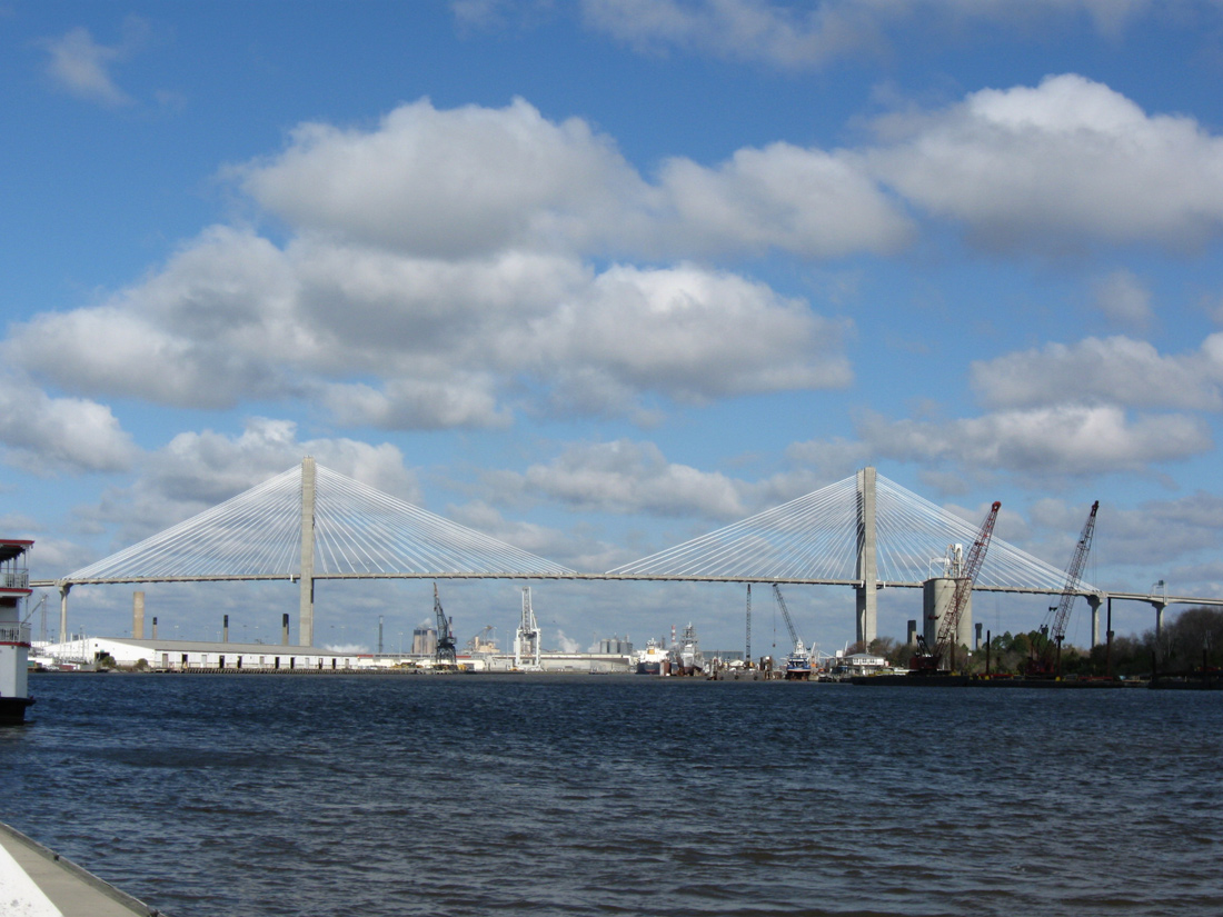
U.S. 17 overlaps with SR 25 northward from the Florida state line through Brunswick, Richmond Hill and Savannah. The pair overlap with Interstate 516, U.S. 80 and SR 21 between Ogeechee Road and I-16. Splitting with SR 25 at I-16, U.S. 17 turns east toward the Downtown Savannah and the Eugene Talmadge Bridge across the Savannah River. SR 25 remains alongside I-516/U.S. 80 northwest to Garden City, following the original U.S. 17 alignment to Port Wentworth and the Houlihan Bridge into South Carolina.
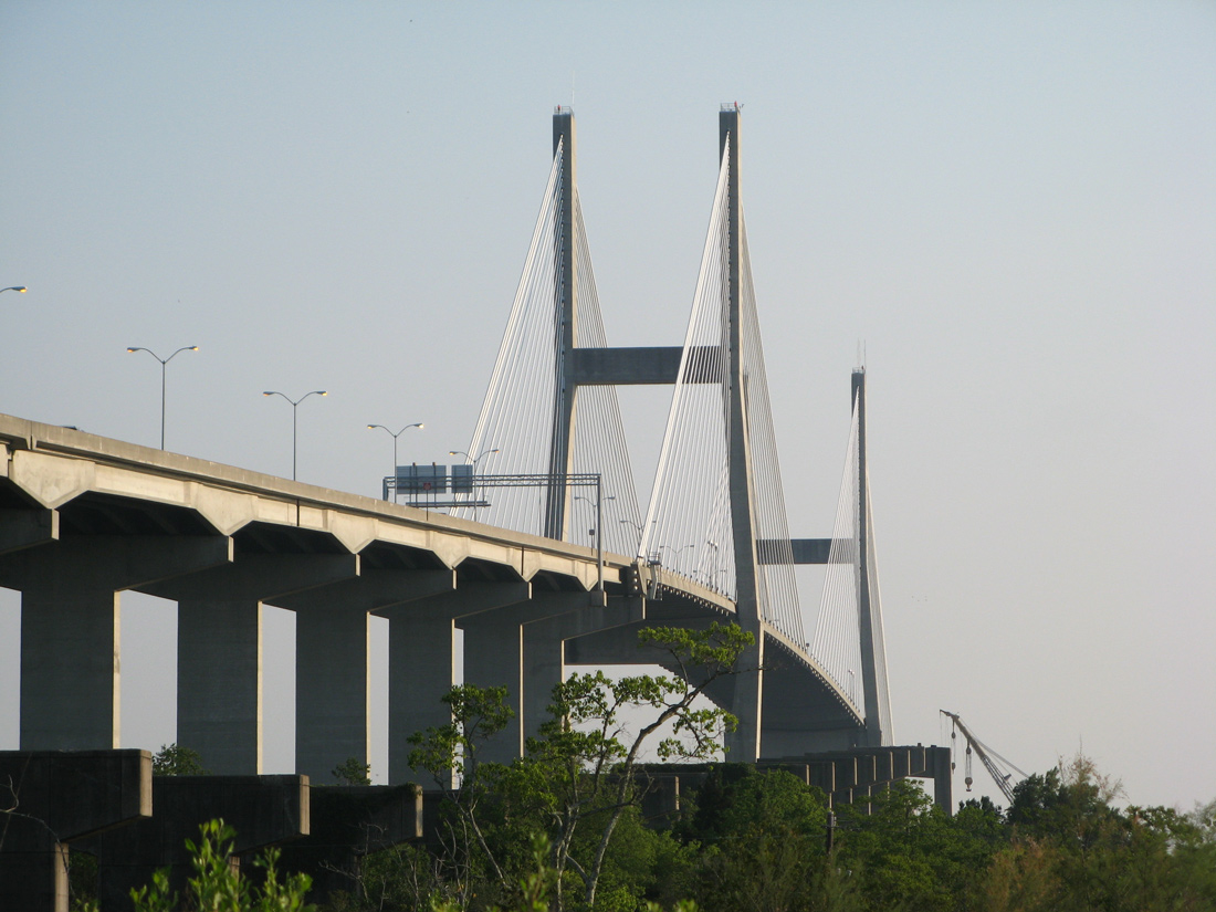
U.S. 17 was relocated onto the Eugene Talmadge Bridge in 1988, replacing U.S. 17 Alternate across the Savannah River at Hutchinson Island. Prior to completion of the cable stayed bridge and approach freeway (SR 404 Spur) from I-16 in 1991, U.S. 17 followed surface streets to the predecessor two lane Talmadge Bridge. U.S. 17 Alternate was posted in lieu of the U.S. 17 mainline due to the previous toll collection at the Savannah River crossing. Tolling ceased in 1975.
Initially costing $14.4 million, the 60 year old bridge carrying U.S. 17 across the Back River, from Hutchinson Island in Georgia to Jasper County, South Carolina, was replaced in a two year project. Plans to build a new bridge originated in 2007, and work was finally underway in July 2013. With federal funds paying for 80% of the cost, the new span is 3 feet higher and supports a wider deck with 8 foot shoulders in each direction.8 With total costs at $16.4 million, the 0.6 mile long bridge opened with two-way traffic in August 2015.9 Subsequent work expands U.S. 17 northward from the Back River to four lanes, and will add a second span once funding becomes available.

Guides:
U.S. 80 – Louisville Road / Victory Drive
Interstate 16 replaced U.S. 80 (Louisville Road) as the main route between Savannah and Statesboro to the west. Paired with SR 26, U.S. 80 serves local traffic east from the southern corner of Effingham County east to the city of Bloomingdale. SR 30 overlaps with the US highway east from the county line to SR 17. SR 30 turns north along side SR 17, as SR 17 south joins U.S. 80 east for 2.5 miles to Cherry Street in Bloomingdale.
A two phase project started in 2017 constructed an interchange at the south end of Jimmy DeLoach Parkway and U.S. 80. The exchange supports a 2.73 mile long southward extension of the parkway to I-16. The project completion date was September 13, 2022.
East into Pooler, U.S. 80/SR 26 meet Pooler Parkway, a controlled access arterial, at a parclo interchange before separating into the one way couplet of Collins Street east and Louisville Road west through the Pooler city center.
Traffic along U.S. 80/SR 26 combines along Louisville Road, a four lane arterial ahead of Interstate 95 and industrial areas of east Pooler. With a continuous center turn lane, U.S. 80 continues east to Garden City and north to Bay Street along side I-516/SR 21 (W.F. Lynes Parkway). U.S. 80 combines with the freeway south around the west side of Savannah to Ogeechee Road.
Victory Drive extends U.S. 80 east from Ogeechee Road through Midtown Savannah and the town of Thunderbolt. A high level bridge spans the Wilmington River onto Whitemarsh Island, with U.S. 80 traversing coastal areas and marshland to Fort Pulaski National Monument and Tybee Island. U.S. 80 ends at the intersection of Butler Avenue and 17th Street, just a tenth of a mile from the Tybee Beach Pier and Pavilion on the Atlantic Ocean.
Prior to 1941, U.S. 280 overlapped with U.S. 80 east from Blichton to U.S. 17 at the intersection of Liberty and Montgomery Streets in Savannah.
State Routes

Guides:
Georgia State Route 17
A rural route linking Interstate 16 with Bloomingdale, and U.S. 80 with city of Guyton in Effingham County, SR 17 stays west of U.S. 17. Prior to 2020, SR 17 concluded at I-16 south from U.S. 80/SR 26 in Bloomingdale. The route was realigned onto Jimmy DeLoach Parkway 8.86 miles east from U.S. 80/SR 26 to SR 21 ALT at the Sonny Dixon Interchange in Port Wentworth.

Guides:
Georgia State Route 21 – Augusta Road, DeRenne Avenue
SR 21 begins at the intersection of DeRenne Avenue and Abercorn Street (SR 204) at Midtown Savannah. DeRenne Avenue comprises a major arterial route between Truman Parkway and Interstate 516 (Lynes Parkway). DeRenne Avenue upgrades to Lynes Parkway west of Montgomery Street. There SR 21 and Interstate 516 commence a 6.68 mile long overlap northwest to Garden City. The north end of the freeway directly transitions into Augusta Road, a five lane boulevard to Port Wentworth.
SR 21 forms a busy truck route between Interstate 95 and the Port of Savannah. Some traffic relief was provided to the route when the Jimmy DeLoach Parkway extension opened to traffic to the east of SR 21, and south to SR 307. The 3.1 mile long limited access link was expected to accommodate over 8,000 trucks per day traveling between the Georgia Port Authority (GPA) Garden City Terminal and I-95/16. $100 million in bonds were sold for the project by the state of Georgia. Ground breaking on the parkway took place on October 17, 2013. Attended by Governor Nathan Deal, a formal ribbon cutting ceremony officially opened the new route on May 27, 2016.10
North from Bonnybridge Road, SR 21 combines with SR 30 to a point just north of Interstate 95 in Port Wentworth. The busy exchange between the two routes and I-95 was redesigned into a diverging diamond interchange (DDI) by January 2017 to improve traffic flow. Beyond Chatham County, SR 21 advances northwest to Springfield in Effingham County.

Guides:
Georgia State Route 17 Connector – Jimmy DeLoach Parkway
SR 17CO was established in 2020 along Bloomingdale Road north from Interstate 16 at Exit 152. Construction through October 2021 upgrades Bloomingdale Road with an extension of Jimmy DeLoach Parkway south from U.S. 80/SR 26. Jimmy DeLoach Parkway northeast from U.S. 80/SR 26 was numbered as SR 17 in 2020.

Guides:
Georgia State Route 21 Alternate – Jimmy DeLoach Connector
SR 21AL is a limited access expressway extending south from the Sonny Dixon Interchange with Jimmy DeLoach Parkway (SR 17) to SR 307 (Dean Forest Road) in Port Wentworth. Completed in 2016, the 3.46 mile long route was constructed to improve access to the Port of Savannah.

Georgia State Route 21 Spur – Brampton Road
Signed with east and west banners, SR 21 Spur follows Brampton Road 1.22 miles northeast from SR 21 (Augusta Road) in Garden City to Gate #2 of the Georgia Ports Authority terminal.

Guides:
Georgia State Route 25 – Coastal Highway
SR 25 represents the state route counterpart for U.S. 17 north from the Florida state line to their shared alignment with Interstate 516 and U.S. 80 on Lynes Parkway. U.S. 17 separates with SR 25 to follow I-16 east to the Talmadge Bridge while SR 25 stays along I-516 north to Main Street through Garden City. SR 25 continues north along the pre-1989 alignment of U.S. 17 to Port Wentworth and east across the Savannah River on the Houlihan Bridge. South Carolina Highway 170 (Alligator Alley) extends east from SR 25 back to U.S. 17.

Guides:
Georgia State Route 25 Connector – Bay Street
SR 25 Connector links Interstate 516, U.S. 80, and SR 21-25 at Garden City with Downtown Savannah and U.S. 17/SR 404 Spur across the Eugene Talmadge Bridge. The state route travels 3.12 miles clockwise along a combination of Bay Street east, Martin Luther King, Jr. Boulevard south and Oglethorpe Avenue west to the Talmadge Bridge south approach.

Georgia State Route 26
Like SR 25, SR 26 represents a state route counterpart for a U.S. highway. SR 26 follows U.S. 80 throughout Chatham County, and overall west to Dublin and Dudley. SR 26 is well marked along the overlap with U.S. 80.
SR 26 Loop was the original designation for the Savannah Bypass (W.F. Lynes Parkway). The state route branched south from U.S. 80 (Augusta Avenue / Main Street) in Garden City to DeRenne Avenue at Midtown Savannah. DeRenne Avenue continued the route east to La Roche Avenue. An unbuilt eastern leg would have returned SR 26 Loop to SR 26 at Thunderbolt.

Georgia State Route 26 Connector – Burnsed Boulevard
SR 26CO links U.S. 80/SR 26 at Haslam Avenue with the exchange joining SR 25 with I-516/SR 21 (W.F. Lynes Parkway) in Garden City. The 0.20 mile long route follows Burnsed Boulevard.

Guides:
Georgia State Route 30
SR 30 travels east from SR 17 in southern Effingham County to SR 21 at Port Wentworth in northern Chatham County. SR 30 is generally rural, though suburban development appears along the route in Port Wentworth. SR 30 ends 0.94 miles east of SR 21 (Augusta Road) at SR 25 (Coastal Highway) near the Houlihan Bridge.

Guides:
Georgia State Route 204 – Abercorn Street
SR 204 (Abercorn Street) forms the main commercial corridor through Southside and Midtown Savannah. The state route originates from U.S. 280 at Lanier in northern Bryan County. Following a rural course, SR 204 enters western Chatham County parallel to the Ogeechee River. Annexed areas of Savannah extend west along the route beyond the interchange with Interstate 95.
Meeting I-95 near Richmond Hill, SR 204 expands into Abercorn Street Extension, a four to six lane divided highway leading east to Southside Savannah. Growing commuter traffic overwhelmed the route, fueling a $26.9 million project to construct an interchange in place of a signalized intersection at King George Boulevard. The new ramps opened to traffic on January 19, 2017. Part of an overall SR 204 improvement project through early 2017, work at King George Boulevard commenced on May 15, 2014.11
A third interchange along Abercorn Street Extension joins SR 204 with Veterans Parkway north. Veterans Parkway leads commuters north to I-516 in the vicinity of Hunter Army Airfield, while SR 204 plies east through a congested commercial strip anchored by Savannah Mall and Armstrong State University.
Curving north at the split with Harry S. Truman Parkway, Abercorn Street Extension remains a slow moving commercial arterial to Oglethorpe Mall and DeRenne Avenue (SR 21). The east end of SR 204 was truncated from I-16 at the 37th Street Connector to SR 21 at DeRenne Avenue in 2020. The former route along a tree lined section of Abercorn Street through residential areas of Midtown Savannah was turned over to local maintenance.
Advancing north, SR 204 (Abercorn Street) formerly intersected U.S. 80/SR 26 (Victory Drive) and then turned west onto 37th Street. The 37th Street Connector connects with Interstate 16 at Exit 165.

Guides:
Georgia State Route 307 – Dean Forest Road
SR 307 forms an 8.47 mile long arc along Dean Forest Road between Garden City and Pooler. SR 307 originates at U.S. 17/SR 25 (Ogeechee Road) and heads north to I-16, U.S. 80/SR 26 (Louisville Road), SR 21 and SR 25 (Coastal Highway). The state route formerly served the passenger terminal of Savannah International Airport (SAV) until it was relocated off Airways Avenue and I-95 to the west.
Planned construction at SR 307 (Dean Forest Road) and Interstate 16 will convert the diamond interchange into a DDI.
Decommissioned Routes

Guides:
Toll U.S. 80 – Islands Expressway
Toll U.S. 80 lined a combination of Bay Street, General McIntosh Boulevard, President Street Extension and Islands Expressway to provide a through route for U.S. 80 between Downtown Savannah and Whitemarsh Island. The Sam Varnedoe Bridge along Islands Expressway at the Wilmington River was tolled until 1980. When tolls were lifted, the bannered route was retired.

Guides:
Former Georgia State Route 167 – Chatham Parkway
Chatham Parkway is a four mile long arterial route winding north from Garrard Avenue, by the Brandlewood community, to U.S. 80/SR 26 (Louisville Road) in Garden City. Maintained by Chatham County, the four lane parkway was originally planned as SR 167. The designation appeared on 1970s official state maps and guides signs for Chatham Parkway on both I-16 and Veterans Parkway included space for a state route shield.

Guides:
Former Georgia State Route 204 Spur – Montgomery Cross Rd, Waters Ave, Whitefield Ave, Diamond Cswy
Signed in 1990, SR 204 Spur was a 7.2 mile long route southeast from SR 204 (Abercorn Street Extension) in south Savannah to McWorther Drive / Green Island Road on Skidaway Island. SR 204 Spur followed Montgomery Cross Road east from Abercorn Street Extension to Waters Avenue south.
Continuing onto Whitefield Avenue, SR 204 Spur connected with Harry Truman Parkway at a diamond interchange. Diamond Causeway turned the route east across the inland marshes, the Moon River and Skidaway Narrows onto Skidaway Island.
Diamond Causeway crossed the Intracoastal Waterway at Skidaway Narrows over a 188 foot long draw bridge until October 12, 2013. Built in 1970, the low clearance span was replaced by a new 2,160 foot long fixed high rise bridge with a 65 foot clearance.12 Delayed for ten and a half months due to substandard girders, the new Diamond Causeway Bridge cost $22.5 million.13 The former span was demolished in December 2013.12

Former Georgia State Route 359 – 37th Street, Abercorn Street Extension
SR 359 was a temporary designation applied to 37th Street east from Broad and Montgomery Streets, then both U.S. 17 and U.S. 80, to Abercorn Street. Abercorn Street Extension continued the route south to Southside Savannah. These alignments became SR 204.

Former Georgia State Route 367 – Johnny Mercer Boulevard
SR 367 followed Johnny Mercer Boulevard, the original alignment of U.S. 80, on Whitemarsh and Wilmington Islands east of Thunderbolt and west of Fort Pulaski National Monument. The state route was decommissioned by 1984.
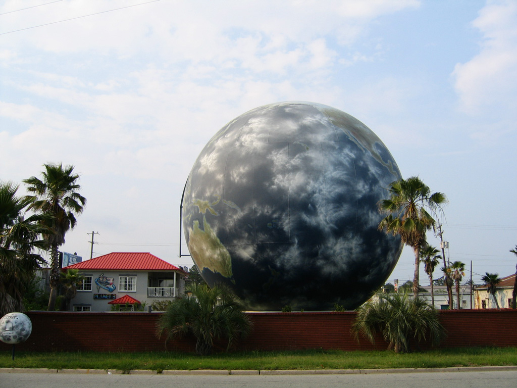

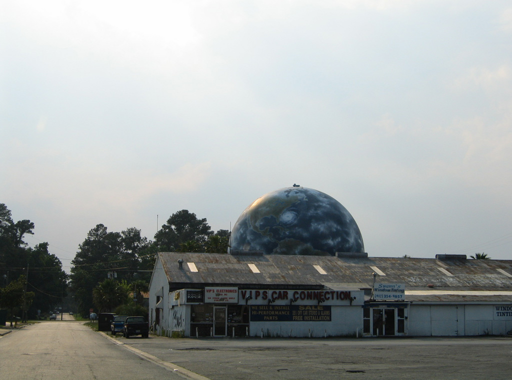
The Savannah Globe or World Globe Gas Storage Tank lies along 73rd Street between White Bluff Road and Abercorn Street (SR 204). This locally famous landmark was built as a natural gas storage tank in 1956-57 by the Savannah Gas Company and painted two years later to resemble a globe, with an arrow pointing to “Savannah is here”. Measuring 60 feet in diameter, the tank remained in operation until the 1970s, and under the ownership of the Savannah Gas Company (later the Atlanta Gas Company) until the early 1990s. Rusting and deteriorating by the late 1990s, A to Z Coating & Sons purchased the structure and embarked on repainting the globe for the year 2000.15 The new paint job simulated topography and cloud cover, complete with a hurricane bound for Savannah. The globe was again sold to the Savannah Mortgage Co by September 2005. at a cost of around $450,000.16
Savannah Street Scenes

Abercorn St north
A small guide sign once directed motorists onto Liberty Street east from Abercorn Street north for both I-16 and Truman Parkway. Liberty Street to Broad Street is the through route to President Street. 03/15/10.
Abercorn St north
The city-installed sign for I-16 and Truman Parkway on Abercorn Street north at Liberty Street was taken down sometime after 2007. Liberty Street west leads to Martin Luther King, Jr. Boulevard just north of the westbound beginning of Interstate 16 otherwise. 03/15/10.
Abercorn St north
Abercorn Street north and Oglethorpe Avenue come together at the northwest corner of Colonial Park Cemetery. 05/29/07.
Abercorn St north
Aberncorn Street heads one block north from Oglethorpe Square to intersect Broughton Street. Broughton Street heads west to the Savannah financial district. 05/29/07.
Abercorn St north
Abercorn Street north at Bay Street, the former alignment of Toll U.S. 80. A nearby ramp lowers from Bay Street to River Street. 05/29/07.
Abercorn St south
Abercorn Street south at Broughton Street. 05/29/07.
Abercorn St south
Abercorn Street south at Liberty Street. 03/15/10.
Abercorn St south
Abercorn Street south at Henry Street. 03/15/10.
Abercorn St south
Abercorn Street south at Anderson Street. 03/15/10.
Abercorn St south
Older traffic signals in operation at 37th Street, where Georgia 204 joins Abercorn Street south from the west. 03/15/10.
Abercorn St south
Georgia 204 overlays Abercorn Street south from 37th Street as the street expands into an urban arterial. 03/15/10.
Bay St east
Bay Street eastbound at Montgomery Street and Downtown Savannah. Bay Street represents the historic alignment of Toll U.S. 80, an alternate route for Victory Drive east to Oatland Island. 05/29/05.
Bay St east
Broad Street east at Dayton Street south in Downtown Savannah. 05/29/07.
Bay St east
Bay Street east at Abercorn Street, one block north of Reynolds Square in Downtown Savannah. 05/29/07.
Bay St east
Bay Street east at Lincoln Street. 05/29/07.
Bay St east
Bay Street east at Broad Street. Broad Street provides a north-south through route along the east edge of the Savannah central business district. 05/29/05.
Bay St east
Bay Street eastbound at East Broad Street. 05/29/07.
Gen. McIntosh Bl east
The former alignment of General McIntosh Boulevard east at its merge with President Street. This roadway was closed during the President Street Project in 2015. 05/29/07.
E Broad St north
I-16 trailblazer posted along East Broad Street north at Bay Street in Downtown. This assembly was removed by 2012. 03/15/10.
E Broad St south
East Broad Street south approaching President Street, which leads east from historic Downtown Savannah to Truman Parkway. 03/15/10.
Broad St south
Broad Street travels south from Bay Street along the eastern edge of Historic Downtown Savannah to U.S. 80 (Victory Drive), Pictured here is the southbound intersection with President Street. 05/29/05.
E Broad St south
President Street stems east from East Broad Street as a four-lane, urban arterial to overtake General McIntosh Boulevard ahead of Truman Parkway. 03/15/10.
E Broad St south
East Broad Street south at Oglethorpe Avenue. 03/15/10.
E Broad St south
Liberty Street comprises a through street west from East Broad Street to Interstate 16. 03/15/10.
Broughton St east
One block east from its beginning, Broughton Street intersects Montgomery Street (old U.S. 17 north / 80 west). 05/29/05.
Broughton St east
Broughton Street eastbound at Jefferson Street. Broughton Street travels through the Savannah central business between the city squares along Congress and State Streets. 05/29/05.
Broughton St east
Street level traffic lights operate at several of the intersections along Broughton Street, including here at Barnard Street. 05/29/05.
Broughton St east
Whitaker Street flows south from Bay Street across Broughton Street to Forsyth Park. 05/29/05.
Broughton St east
Bull Street intersects Broughton Street east between Johnson and Wright Squares. 05/29/05.
Broughton St east
Broughton Street proceeds east one block from Bull Street to meet Drayton Street north. 05/29/05.
Broughton St east
Continuing east through Downtown, Broughton Street intersects Abercorn Street. The northeast corner of the intersection is home to the Savannah College of Art & Design Trustees Theater. 05/29/05.
Broughton St east
Broughton Street east transitions into a residential street at Habersham Street. 05/29/05.
Broughton St east
Broughton Street meets Broad Street two blocks beyond this traffic light at Price Street. 05/29/05.
Broughton St west
Broughton Street west at Abercorn Street in Downtown Savannah. 07/29/05.
Broughton St west
Drayton Street flows north from Forsyth Park to end three blocks north of Broughton Street at Bay Street. 07/29/05.
Drayton St north
Drayton Street north at Liberty Street. 03/15/10.
Drayton Street north
Drayton Street north ends at Bay Street above Factoru's Walk on River Street. 05/29/07.
Gwinnett St west
Gwinnett Street west at Habersham Street, three blocks ahead of Forsyth Park. 03/15/10.
Habersham St north
Older traffic lights at the intersection of Habersham Street north and 37th Street (Georgia 204). 03/15/10.
Habersham St north
Older traffic lights at the intersection of Habersham Street north and 37th Street (Georgia 204). 03/15/10.Sources:
- Savannah Convention & Visitors Bureau.
http://www.savcvb.com/savannah - “Savannah’s ‘iron curtain’ may be torn down.” Savannah Morning News (GA), May 21, 2016.
- “Proposed I-16 work promises widening, safety.” Savannah Morning News (GA), June 28, 2016.
- “GDOT to begin project to improve sight on I-516 interchange.” WTOC11 (Savannah, GA) April 20, 2017.
- “UPDATE: Highway 21 Diverging Diamond Interchange Now Open.” WSAV (Savannah, GA), January 15, 2017.
- “Road More Traveled – The Georgetown Area Has Upward of $1O Million in Retail Space Under Construction, and That’s Only the Beginning of the Growth the Southwest Bypass Will Encourage.” Savannah Morning News (GA), July 18, 1999.
- “Drive Through! – Veterans Parkway Flyover Opens, Easing Commuter into Savannah More Than Two Years and $29.5 Million Worth of Construction on GA. 204 Nears Completion with Wednesday’s Road Opening. Officers Will be in Place to Ensure Transition Goes Smoothly.” Savannah Morning News (GA), October 24, 2002.
- “New Back River Bridge to cost extra $2 million.” Savannah Morning News (GA), February 10, 2015.
- “Savannah’s Back River Bridge opens for business.” The Island Packet (Hilton Head Island, SC), August 7, 2015.
- “Jimmy DeLoach Parkway connector ready for trucks.” Effingham Herald (GA), June 1, 2016.
- “New State Route 204 interchange on-ramp set to open Thursday.” WTGS Fox 28 (Savannah, GA), January 18, 2017.
- “Portion of Old Skidaway Narrows Bridge Demolished.” Savannah Morning News (GA), December 11, 2013.
- “Skidaway Bridge Opens – Contractor Now Dismantling Old Drawbridge.” Savannah Morning News (GA), October 15, 2013.
Page updated June 8, 2021.