Interstate 5 begins at the San Ysidro Port of Entry at the International Border with Mexico and extends north through or near several cities, including San Diego, Santa Ana, Los Angeles, Coalinga, Tracy, Stockton, Sacramento, Redding, and Yreka. It continues into Oregon and Washington en route to Portland and Seattle before ending at the International Border with Canada near Blaine, Washington. Interstate 5 is arguably one of the most important highways in California, connecting the state from the rural extremes of the north to the farm land of the Central Valley to the vastly populated urbanscape of the Southland. The freeway is the lifeline of the state, connecting to most of the major population centers, including Southern California, the Central Valley, and Northern California.
This freeway was built in stages between the 1950s and the 1980s, with the last segment opening along a rural stretch north of Redding. Interstate 5 replaced U.S. 99 for much of its journey in the state, from downtown Los Angeles north to the Oregon State Line. Even though California 99, the successor to U.S. 99 in the Central Valley, is still an extant freeway of its own, most through traffic opts for Interstate 5, including the Los Angeles to San Francisco traffic.
Interstate 5 California Guides

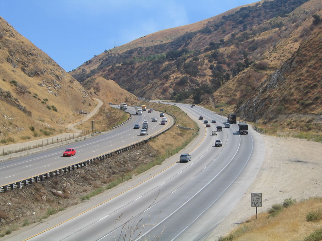
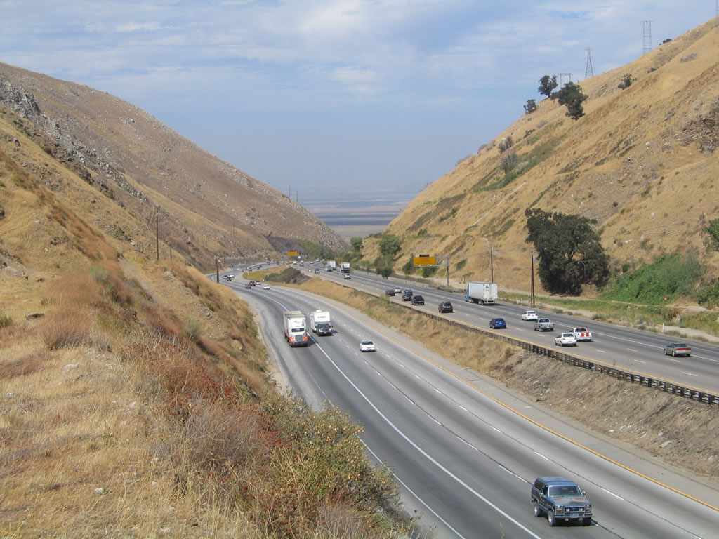
The Central Valley looms on the horizon along Interstate 5 (Golden State Freeway) on the Grapevine grade. The eight-lane freeway is one of the busiest rural freeways in the state, as it serves part of the main route from Northern California to Los Angeles. 09/25/05
The following provides a brief overview of the history of Interstate 5 in San Diego, as well as some projects that improved the freeway:
- 1954. $1,335,000 was spent on 1.4 mile segment of U.S. 101 to bypass Mission Bay Drive around Balboa Avenue (California 274). This section of the U.S. 101 freeway is commonly referred to as the "Balboa Avenue Bypass" until it is linked with the Pacific Highway segment of the U.S. 101 freeway by 1959.
- 1955. The last of several contracts for the construction of the U.S. 101 freeway between the south city limits of Carlsbad and Camp Pendleton was completed.
- 1957-1958. Montgomery Freeway (U.S. 101) between Mexican Border and National City upgraded to full freeway status with completion of interchanges at Dairy Mart Road, 27th Street, and Palomar Street. Planning between the Federal General Services Administration and the California Department of Highways and Public Works begins for an expansion of the Port of Entry (POE) at San Ysidro border crossing.
- 1958. Planning begins on construction of U.S. 101 freeway between north city limits of San Diego and south city limits of Carlsbad, via Del Mar, Solana Beach, Encinitas, and Leucadia with the approval of the State Highway Commission. There are no budgeted plans to convert U.S. 101 through Camp Pendleton into a four-lane freeway at this time.
- 1958-1959. Pacific Highway segment of U.S. 101 under construction to be converted to full freeway standards between Laurel Street and Barnett Avenue. During the 1960s, this alignment is abandoned in favor a new alignment over India Street. This section of Pacific Highway is still maintained as a freeway by the City of San Diego today, complete with old signage.
- 1959-1960. U.S. 101 freeway under construction between National City and San Diego. This freeway will connect several discontinuous segments of San Diego regional freeways, including California 94 (Martin Luther King Jr. Freeway), U.S. 80 (Interstate 8), U.S. 395 (SR-163), and the City of San Diego's Wabash Boulevard (California 15). The U.S. 395 four-level interchange is considered to be the most extensive and complex interchange of the new U.S. 101 freeway construction. The section of U.S. 101 between Market and Laurel Streets is projected to cost $13,000,000 in Fiscal Year 1960.
- 1962. A Texaco Map shows U.S. 101 at freeway grade along the Montgomery Freeway in the South Bay, at the Balboa Avenue Bypass, and around Carlsbad and Oceanside. U.S. 101 is routed along current Gilman Drive, which used to bisect the University of California at San Diego campus. Today, this old alignment is removed from service.
- 1966-1967. Entire Interstate 5 (U.S. 101) freeway complete between National City north to Rosecrans Street, while it is under construction through Rose Canyon north of Balboa Avenue Bypass. Ardath Road and future California 52 interchange also under construction as a part of this project. Old Mission Bay Drive near Balboa Avenue commissioned as Business Loop I-5, which is still signed today.
- Late 1960s. Interstate 5 constructed and opened to traffic between Friars Road and De Anza Cove on east bank of Mission Bay.
- 1971. Entire Interstate 5 freeway completed; remaining U.S. 101 signs are removed.
- 1970s. Business Loop I-5 routed along Pacific Highway and Harbor Drive briefly in the early 1970s, although some maps show this designation as late as the 1990s. Signage is gone by the late 1970s.
- Mid-1995. Phase One of I-5/805 and California 56 interchange upgrade ($52,000,000).
- Early 1996. Southbound auxiliary lanes completed along Interstate 5 in Del Mar area ($8,000,000).
- 1999. Interstate 5 High Occupancy Vehicle (HOV/Carpool) Lanes at I-5/805 and California 56 merge under construction, and direct connections from northbound I-5 to eastbound California 56 and from westbound California 56 to southbound I-5 are completed. Other direct transitions at this interchange (south to east and west to north) were proposed but went unfunded. As for the HOV lanes, the lanes between I-805 and Del Mar Heights Road were completed, additional HOV lanes were to be constructed between Del Mar Heights Road and Birmingham Drive. HOV lanes were planned to extend all the way to California 76 in Oceanside by 2020.
- Spring 2000. Plans announced to realign the Interstate 5/San Ysidro border crossing into Mexico with an unspecified completion date.
- Summer 2000. Additional details provided on the proposed dual freeway for Interstate 5 from I-805 north to Del Mar Heights Road. The local planning agency, SANDAG, anticipated widening the existing eight-lane freeway by adding two HOV express lanes and a six-lane outer separation ("dual freeway") for all trucks and local traffic exiting at Carmel Valley Road or California 56. This project, conducted in five stages, was estimated to cost over $170 million. The construction of the dual freeway began with the two new northbound lanes between Carmel Mountain Road and Del Mar Heights Road along Interstate 5. This construction started in 1995. Plans called for this segment of I-5 to be 12 to 14 lanes wide. By 2003, there were to be three lanes on either side of the main freeway. These three lanes will handle local traffic, while the main four lanes serve through traffic. Right-of-way for this expansion was previously been secured, and some sound walls were likely to be constructed as mitigation to the freeway's neighbors.
- Spring 2001. Caltrans announced a signage replacement program for all Interstate highways in the state, and these signs featured exit numbers. The first such sign along Interstate 5 in San Diego County was for Exit 1B to Via de San Ysidro along northbound.
Many thanks to Merle F. McClelland for his assistance in creating this historical chronology.
Statewide Opening Dates of Interstate 5
- Mexico Border to Interstate 805 - July 13th, 1973
- Interstate 805 to Coronado Avenue - Circa 1955
- Coronado Avenue to E Street - Circa 1952
- E Street to 24th Street - November 15th, 1991
- 24th Street to 18th Street - August 19th, 1965
- 18th Street to Vesta Street - September 1st, 1965
- Vesta Street to Island Street - February 28th, 1964
- Island Street to India Street - Circa 1963
- India Street to Pacific Highway - August 30th, 1965
- Pacific Highway to Old Town Avenue - April 17th, 1967
- Old Town Avenue to San Diego River - July 21st, 1969
- San Diego River to Sea World Drive - July 26th, 1967
- Sea World Drive to De Anza Road - June 2nd, 1969
- De Anza Road to Damon Street - Circa 1954
- Damon Street to Interstate 805 - June 21st, 1966
- Interstate 805 to Poinsettia Avenue - Circa 1963
- Poinsettia Avenue to Palomar Airport Road - June 21st, 1966
- Palomar Airport Road to north city limits of Oceanside - Circa 1953
- North city limits of Oceanside to Las Pulgas Road - October 23rd, 1967
- Las Pulgas Road to San Onofre Creek - May 23rd, 1968
- San Onofre Creek to Cristanitos Road - November 20th, 1968
- Cristanitos Road to El Camino Real - Circa 1958
- El Camino Real to San Juan Road - Circa 1960
- San Juan Road to Junipero Serra Road - Circa 1958
- Junipero Serra Road to El Toro Road - Circa 1959
- El Toro Road to Red Hill Avenue - Circa 1958
- Red Hill Avenue to California 22 - Circa 1955
- California 22 to Orange/Los Angeles County Line - Circa 1957
- Los Angeles County Line to Shoemaker Avenue - Circa 1955
- Shoemaker Avenue to Pioneer Boulevard - Circa 1954
- Pioneer Boulevard to Washington Boulevard - Circa 1953
- Washington Boulevard to Indiana Street - Circa 1951
- Indiana Street to California 60 - Circa 1948
- California 60 to Fourth Street - Circa 1960
- Fourth Street to Interstate 10 - Circa 1959
- Interstate 10 to Pasadena Avenue - Circa 1960
- Pasadena Avenue to California 110 - Circa 1962
- California 110 to Glendale Boulevard - Circa 1961
- Glendale Boulevard to Alameda Avenue - Circa 1957
- Alameda Avenue to Magnolia Boulevard - Circa 1959
- Magnolia Boulevard to Roscoe Boulevard - Circa 1960
- Roscoe Boulevard to Lankershim Boulevard - Circa 1961
- Lankershim Boulevard to Interstate 210 - Circa 1963
- Interstate 210 to Weldon Canyon Road - Circa 1955
- Weldon Canyon Road to Calgrove Boulevard - October 13th, 1967
- Calgrove Road to Valencia Boulevard - October 19th, 1967
- Valencia Boulevard to California 126 - February 11th, 1965
- California 126 to Lake Hughes Road - November 20th, 1968
- Lake Hughes Road to Templin Highway - August 27th, 1970
- Templin Highway to Gorman Road - October 23rd, 1967
- Gorman Road to Grapevine Creek - September 1st, 1966
- Grapevine Creek to California Aqueduct - Circa 1960
- California Aqueduct to California 99 - December 23rd, 1969
- California 99 to California 119 - March 1st, 1972
- California 119 to Rowlee Road - February 4th, 1970
- Rowlee Road to California 46 - August 21st, 1967
- California 46 to Weiser Road - November 11th, 1970
- Weiser Road to California 41 - February 25th, 1972
- California 41 to Avenal Cutoff - May 1st, 1969
- Avenal Cutoff to California 33 - September 29th, 1970
- California 33 to California 152 - March 1st, 1972
- California 152 to Whitworth Road - June 13th, 1966
- Whitworth Road to Gaffery Road - November 1st, 1967
- Gaffery Road to Paradise Cutoff - November 23rd, 1971
- Paradise Cutoff to Roth Road - July 1st, 1972
- Roth Road to Eighth Street - October 25th, 1971
- Eighth Street to Stockton Viaduct - September 30th, 1972
- Stockton Viaduct to Benjamin Holt Drive - July 18th, 1970
- Benjamin Holt Drive to Hammer Lane - November 23rd, 1971
- Hammer Lane to Thornton Road - February 7th, 1978
- Thornton Road to Walnut Grove Road - September 21st, 1979
- Walnut Grove Road to Dierssen Road - October 12th, 1979
- Dierssen Road to Beach Lake Road - October 22nd, 1975
- Beach Lake Road to California 160 - November 22nd, 1974
- California 160 to Sutterville Road - January 2nd, 1975
- Sutterville Road to Business Loop I-80 and U.S. 50 - July 15th, 1970
- Business Loop I-80 and U.S. 50 to California 275 (Tower Bridge) "Boat Section" - January 21st, 1971
- California 275 to Sacramento Viaduct - July 15th, 1970
- Sacramento Viaduct to Richards Boulevard - February 11th, 1969
- Richards Boulevard to Garden Highway - October 17th, 1968
- Garden Highway to California 99 - August 7th, 1968
- California 99 to WN Canal - December 18th, 1968
- WN Canal to County Road 22 - July 9th, 1969
- County Road 22 to County Road 102 - September 19th, 1969
- County Road 102 to California 16 - April 3rd, 1973
- California 16 to Interstate 505 - August 6th, 1970
- Interstate 505 to County Line Road - October 10th, 1968
- County Line Road to Meyers Road - November 21st, 1967
- Meyers Road to North Maxwell Road - December 2nd, 1971
- North Maxwell Road to County Road 60 - June 23rd, 1970
- County Road 60 to County Road 33 - August 12th, 1966
- County Road 33 to Glenn/Tehama County Line - June 16th, 1966
- Glenn/Tehama County Line to Corning Road - August 29th, 1966
- Corning Road to South Main Street - December 21st, 1965
- South Main Street to North Red Bluff Road - November 11th, 1965
- North Red Bluff Road to Bowman Road - May 1st, 1964
- Bowman Road to Cottonwood Road - August 7th, 1964
- Cottonwood Road to Riverside Avenue - December 9th, 1966
- Riverside Avenue to California 273 - August 19th, 1966
- California 273 to Pit River Road - December 21st, 1967
- Pit River Road to Obrien Road - October 21st, 1968
- Obrien Road to Antler Summit Road - November 21st, 1966
- Antler Summit Road to Roadside Rest Area - August 22nd, 1972
- Roadside Rest Area to Sims Road - Circa 1957
- Sims Road to Sweetbrier Road - Circa 1962
- Sweetbrier Road to Mott Avenue - Circa 1960
- Mott Avenue to Mount Shasta Road - October 16th, 1964
- Mount Shasta Road to North Weed Boulevard - August 6th 1973
- North Weed to Julien Creek Bridge - October 30th, 1969
- Julien Creek Bridge to California 96 south junction - October 9th, 1970
- California 96 south interchange to California 96 north junction - July 1st, 1968
- California 96 north interchange to Bailey Hill Road - August 22nd, 1974
- Bailey Hill Road to Oregon State Line - June 3rd, 1966
Many thanks to C.J. Moon for his assistance in providing this historical chronology.
|
| Trailblazers for I-5 and I-8 posted on northbound Congress Avenue in Old Town San Diego, prior to the Taylor Street intersection near the transit center. 03/18/09 |
|
| Interstate 5 spans the Old Town Transit Center parking lot and Pacific Highway in Old Town San Diego along a ten lane viaduct. 03/18/09 |
|
| Trailblazers direct motorists from Rosecrans Street east onto Pacific Highway (Old U.S. 101) north and south for the respective directions of Interstate 5. 03/18/09 |
|
| Sea World Drive extends west from Tecolote Road across West Morena Boulevard (old U.S. 101) and an adjacent railroad line to meet Interstate 5 just north of I-8. 03/17/09 |
|
| Sea World Drive west at the diamond interchange with Interstate 5 in San Diego's Morena District. 03/17/09 |
|
| Las Pulgas Road at the diamond interchange (Exit 62) with Interstate 5 in Camp Pendleton. A parking area located nearby allows visitors to bicycle or hike along Old U.S. 101. 06/12/01 |
|
| Lyons Avenue west leaves the city of Santa Clarita and changes into Pico Canyon Road en route to Stevenson Ranch at the parclo interchange (Exit 167) with I-5. Interstate 5 north heads from here to Magic Mountain, Castaic and Sacramento. 11/25/04 |
|
| Lyons Avenue passes over Interstate 5 ahead of the loop ramp for Interstate 5 south to Los Angeles. 11/25/04 |
|
| Pico Canyon Road extends west from I-5 to an array of big box stores and apartment complexes. The on-ramp for Interstate 5 south departs from the intersection with Marriott Way. 04/06/12 |
|
| This custom made sign for I-5 shows the lane allocations along Chiquella Lane north at Pico Canyon Road west and Lyons Avenue east. 04/06/12 |
|
| Smokey Bear Road links Pyramid Lake Road (old U.S. 99) with adjacent Interstate 5 at a diamond interchange (Exit 195) in Peace Valley. Guide signs pictured here still referenced Bakersfield for the freeway north. The control city was changed to Sacramento because Interstate 5 does not actually enter Bakersfield. 11/28/02 |
|
| Looking south toward Fort Tejon from a section of abandoned Highway 99 above the west side of Interstate 5 along the Grapevine grade. 09/25/05 |
|
| A 1933 concrete culvert provides drainage for Grapevine Creek under the southbound lanes of Interstate 5. 09/25/05 |
|
| Interstate 5 travels through the Grapevine in order to ascend from the Central Valley into the Tehachapi Mountains. A single-slab, concrete segment of old U.S. 99 appears in this view of I-5 through Grapevine Canyon from Digier Road near the Fort Tejon interchange (Exit 210). 09/25/05 |
|
| This sign for Interstate 5 north predated the 1964 decommissioning of U.S. 99 throughout California. It was located on the Lebec Service Road near Exit 207.
U.S. 99 was cosigned with the Golden State Freeway north to the SR 99 freeway at Exit 221. 09/25/05 |
|
| Trailblazer for the northbound on-ramp from the Lebec Service Road on the east side of I-5 at Exit 207. Old U.S. 99 runs along the west side of the freeway here. 09/25/05 |
|
| A service road loops over Interstate 5 at Exit 207, linking the east side frontage road with old U.S. 99 and the community of Lebec. This sign predates the change of I-5 north to use Sacramento as a control city. 09/25/05 |
|
| Eastbound Panoche Road at the diamond interchange (Exit 368) with Interstate 5 in the Central Valley near Chaney Ranch. 07/15/09 |
|
| Louise Avenue east meets Interstate 5 in the city of Lathrop after Manthey Road. 09/05/10 |
|
| These freeway entrance signs are posted at the on-ramp from the Maxwell Safety Rest Area onto northbound Interstate 5. 08/02/11 |
|
| Westbound Hooker Creek Road meets Interstate 5 at a standard diamond interchange (Exit 657). This view looks west at the on-ramp to Interstate 5 north to Redding. 08/02/11 |
|
| Eastbound Lakeshore Drive approaches Interstate 5 at Exit 702. The freeway leads south to Redding and Sacramento. 05/25/08 |
|
| Passing under the freeway, Lakeshore Drive east approaches Interstate 5 north to Yreka and Portland. Further ahead, Lakeshore Drive connects with Antlers Road, which parallels I-5 on the east side of the freeway through Lakehead. 05/25/08 |
|
| Eastbound Dog Creek Road approaches Interstate 5 at Exit 707. I-5 travels south to Redding and Sacramento and north to Dunsmuir, Yreka and Portland, Oregon. 05/25/08 |
|
| Westbound Sims Road passes under Interstate 5 and approaches the connecting ramp to Interstate 5 south to Redding. This sign is located at Exit 718 in the Sacramento River Canyon. 05/25/08 |
|
| Sims Road east at the northbound on-ramp for I-5 to Dunsmuir. A replacement of this button copy sign made by 2015 corrected the misspelling of Sims Road. 05/25/08 |
|
| Freeway entrance shield assembly for the northbound on-ramp from Castle Creek Road at Exit 724 in Castella. 05/25/08 |
|
| Castle Creek Road east at Interstate 5 north to Dunsmuir. This vintage guide sign dated to 1959, though a reflective overlay was added to its face. The entire assembly was replaced by 2015. 05/25/08 |
|
| Westbound Soda Creek Road enters the diamond interchange (Exit 726) with Interstate 5. The road ends on the west side of the exchange at the Pacific Crest Trail. 05/25/08 |
|
| A short access road links the diamond interchange (Exit 734) of I-5 with parallel Mott Road and Mott Airport Road. Dunsmuir Municipal-Mott Airport (1O6) lies just east of the freeway. 05/25/08 |
Photo Credits:06/12/01, 11/28/02, 11/25/04, 09/25/05, 05/25/08, 03/17/09, 03/18/09, 07/15/09, 09/05/10, 08/02/11, 04/06/12 by AARoads
Connect with:
Interstate 8
Interstate 10
Interstate 15
Interstate 80
Interstate 105
Interstate 110 and State Route 110
Interstate 205
Interstate 405
Interstate 505
Interstate 580
Interstate 605
Interstate 710
Interstate 805
U.S. 97
U.S. 101
State Route 905
Page Updated 01-27-2023.


 scenes